The item illustrated and described below is sold, but we
have another example in stock. To view the example which
is currently being offered for sale, click the
"View Details" button below.
1950 Roads To Romance Inc.
Ride The Roads To Romance along the Golden Coast and thru the Sunshine Empire of Southern California
$ 295.00


|
||

|

|
|

|
Stock# 77236
Description
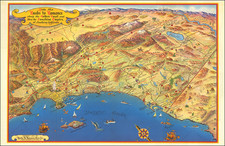
One of the great vintage pictorial maps of Southern California, first published in 1946, with this edition published in 1953.
The coverage of the map extends from Malibu Beach, Topanga Canyon, and Mission San Fernando to Ensenada centered on San Juan Capistrano in the west. Death Valley, Las Vegas, Needles, Parker Dam, and the Salton Sea appear on the horizon.
This quintessential Southern California pictorial map focuses a lot on the history of the region; it depicts the routes of Anza and the Butterfield Stage.
This edition is the last without the decorative vignettes at the sides.
A lively and highly artistic view of Southern California!
Condition Description
Folding map.
![Mexique par Th. Duvotenay…1842 [Republic of Texas]](https://storage.googleapis.com/raremaps/img/small/93713.jpg)