


|
||

|

|
|

|
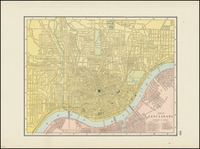
Scarce antique lithographed folding map of Cincinnati, Ohio, issued by local publisher C.S. Mendenhall in 1889.
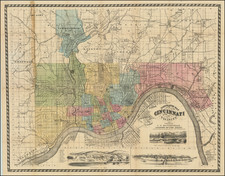
The map covers Cincinnati and some of the communities across the Ohio River. It is hand-colored by ward and includes the names of many of the streets, as well as railroad lines, and names of some of the larger landmarks, parks, and public buildings.
The map has three landscape views of Cincinnati at different times "First Landing at Losantiville Dec. 28th 1788", "Cincinnati in 1802", and "Cincinnati at the Present Time". A key names some of the owners and names of buildings in the 1802 view.
The map includes its original printed covers on which a wood-engraved view "Old Fort Washington, (Cincinnati) 1790." is printed.
Over 10 years ago, we had a later edition of Mendenhall's Cincinnati.
![[ Middle British Colonies Map ] Pensilvania Maryland and Virginia](https://storage.googleapis.com/raremaps/img/small/98228.jpg)
![[Edwinburgh, Ohio] (Millsboro Township, Richland County)](https://storage.googleapis.com/raremaps/img/small/66072.jpg)