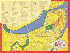


|
||

|

|
|

|
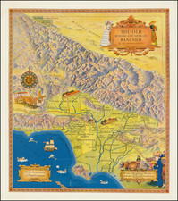
Iconic Eddy Ranchos Map
Marvelous decorative map of Southern California, extending from Los Alamos y Agua Caliente and La Liebre in the Mojave Desert to Los Alamitos, Los Coyotes, and Los Nogales Ranchos in the south. Eddy's map shows the Spanish colonial ranches which pre-date the growth and development of Los Angeles. El Camino Real and the Missions are prominently depicted, along with an attractive compass rose, sailing ship, flying fish, etc. This is one of the few maps to depict the Spanish and Mexican Ranchos and redefines the image of Los Angeles.
Many of the ranchos are remembered in neighborhood and street names, with some of the most famous being Malibu, Los Palos Verdes, Santa Monica, and San Pedro. The two important missions of the area are depicted, San Fernando (founded in 1797) and San Gabriel Arcangel (founded in 1771). The many mountains of Los Angeles County are shown pictorially, and points of interest include Catalina Island in the south and the vast Mojave Desert to the north.
This map was illustrated by Gerald A Eddy in 1937 as an advertisement for the Title Insurance and Trust Company of Los Angeles.
Gerald Allen Eddy moved from Michigan to Southern California in 1902.
From the 1920s, he worked in the Los Angeles area as an artist and commercial cartographer.
Eddy produced a number of pictorial and other maps of the western part of the United States. His earliest work was "Pushing Hun out of Franc eand Belgium" (1918). He produced several other war related maps during WWII, but is best known for his tourist and pictorial maps of California, Nevada and Arizona, including his "The Heart of Arizona" in 1926 and Boulder Dam map of 1931 and his iconic series of maps of Lake Tahoe.