


|
||

|

|
|

|
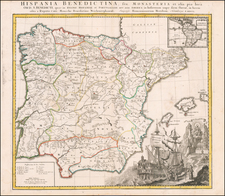
With Naval Battles of the Coast of Catalunya
Scarce late variant edition of Covens & Mortier's map of Northeastern Spain and Catalunya, issued in the midst of the War of Spanish Succession (1701-1714).
The map illustrates the mountains, roadways, and waterways which the armies used to travel the region, including key towns, villages, churches, and universities.
The map include coats of arms of Catalunya, Valencia and Aragon, constituting one sheet of Mortier's 4 sheet map of the Iberian Peninsula.
However, unlike earlier additions, the present map includes several new embellishments, including:
- A depiction of the naval battles off the coast of Catalunya fought in 1705 and 1706.
- Major expansion of the roads and fortifications depicted in Catalunya, Valencia and Aragon, including showing which towns in the region.
Covens & Mortier was one of the largest and most successful publishing firms in Dutch history and continued in business for over a century. Pierre Mortier the Elder (1661-1711) had obtained a privilege in 1690 to distribute the works of French geographers in the Netherlands. After his widow continued the business for several years, Cornelis (1699-1783) took over in 1719.
In 1721, Mortier forged a partnership with Johannes Covens (1697-1774), who had recently married Cornelis’ sister. They published under the joint name of Covens & Mortier. In 1774, upon the death of his father, Johannes Covens II (1722-1794) took over his father’s share. In 1778, the company changed its name to J. Covens & Zoon, or J. Covens & Son.
Covens II’s son, Cornelis (1764-1825), later inherited the business and brought Petrus Mortier IV back into the fold. Petrus was the great-grandson of Petrus Mortier I. From 1794, the business was called Mortier, Covens & Zoon, or Mortier, Covens, & Son.
The business specialized in publishing French geographers including Deslisle, Jaillot, Janssonius, and Sanson. They also published atlases, for example a 1725 reissue of Frederik de Wit’s Atlas Major and an atlas, with additions, from the works of Guillaume Delisle. There were also Covens & Mortier pocket atlases and town atlases. The company profited from acquiring plates from other geographers as well. For example, the purchased Pieter van der Aa’s plates in 1730. Finally, they also compiled a few maps in house. At their height, they had the largest collection of geographic prints ever assembled in Amsterdam.
![(Spanish Riviera) Plan de la Rade de la Carbouiere avec les Quartiers. . . [Plan of the Road of Carbouiere with the Quarters. . .]](https://storage.googleapis.com/raremaps/img/small/94405.jpg)
![[Grenada] Plano de Granada Comprobado con el Instituto Geogco. y Revisado por arquiteto municipal (Spain)](https://storage.googleapis.com/raremaps/img/small/61742.jpg)
![[Basque Coast] Die Zee Custen van Biscaijen tuschen Laredo en Sentillana soe hem dat Selue landt all daer vertthoornt enn opdoet . . . 1583](https://storage.googleapis.com/raremaps/img/small/61468.jpg)