|
||

|

|
|

|
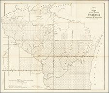
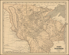
Scarce 1870 pocket map of Wisconsin by Silas Chapman, one of the most important of the early mapmakers of the Upper Midwest.
The map is considerably larger than other editions of Chapman's map. It is hand-colored by counties and showing townships, sections, towns, rivers, lakes, mountains, railroads, and a host of other details.
There are huge counties in the north. Chippewa County extends to Ashland and to Marathon. Marathon extends north to the border w/Canada. Oconto extends to the borders in the east and north and Marathon in the west. The southern part of the state is full of railroads, extending as far north as Fort Borough and Green Bay and in the west to Augusta. Most of the townships in the southern counties are named.
Chapman published numerous editions of this map, as well as other separate maps of Wisconsin under other titles. They are all scarce.
![[ Map of the Mississippi River ]](https://storage.googleapis.com/raremaps/img/small/99811.jpg)