
This item has been sold, but you can enter your email address to be notified if another example becomes available.


|
||

|

|
|

|
Stock# 77092
Description
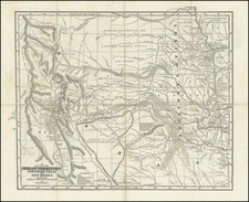
Monumental Map of Texas at the end of the 19th Century
Large format map of Texas, compiled under the direction of Robert T. Hill and Drawn by Henry S. Sleden and Willard D. Johnson.
The map is on a scale of 25 miles = 1 inch and shows counties, towns, railroads, waterways; 250 foot contour lines.
One of the best government published maps of Texas of the period.
Condition Description
Laid on linen, with evidence of old folds, losses and discoloration at folds and bottom left corner.
Reference
Martin, J. & R. pl.50.
![(Texas Revolution) [Manifesto on the Texas Campaign, issued by General Filisola in justification of his conduct, Gen. Santa Anna's correspondence with Vicente Filisola after capture at Battle of San Jacinto, and other documents] Mejicanos [caption title].](https://storage.googleapis.com/raremaps/img/small/94669.jpg)
![[Oklahoma City] Section 22 - T.IIN.-R.3W. Oklahoma City OIl Field](https://storage.googleapis.com/raremaps/img/small/83380.jpg)
![(Panoramic photograph) Camp Travis, Tex. 9/8/1918 East Side [WWI Camp Travis, near San Antonio, Texas, African American Troops]](https://storage.googleapis.com/raremaps/img/small/87312.jpg)
![Karte von Tejas und den angrenzenden Theilen Mejicos . . . [with California Gold Regions Inset]](https://storage.googleapis.com/raremaps/img/small/61669.jpg)