|
||

|

|
|

|
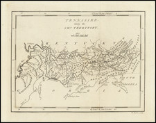
18th Century Nashville Area Daniel Smith Survey on the Cumberland River
Extremely early Nashville area survey map, executed by Tennessee's most important early surveyor, Daniel Smith, executed 4 years prior to the creation of Tennessee, at a time when the land was the "Territory of the United States South of the River Ohio" (Southwest Territory).
General Daniel Smith is one of the most important early figures in the history of Tennessee, the author of the first book on Tennessee and the first map of Tennessee and one of its earliest surveyors, beginning with his appointment August 5, 1781 as Assistant Deputy Surveyor in the Southern Department of the Continental Army under Thomas Hutchins.
The land shown consists of 26 acres on the Cumberland River, opposite Drake's Creek, in today's Green Hill area, near Andrew Jackson's Hermitage Farm. The survey was based upon a grant from Martin Armstrong to Daniel Smith, making Smith both the surveyor and the landowner. The land in question is downstream from the Castle Rock House, Daniel's Smith home built between 1784 and 1796, the oldest house in Middle Tennessee.
Given the location of the land on the opposite side of the Cumberland River from Drake's Creek, it seems likely that the land was intended as ferry location or crossing point to serve Smith's Castle Rock house and plantation, and may be related to the creation of Sanders Ferry. James Sanders (1764-1836) was an assistant to Daniel Smith in the 1780s. In the 1790s, James Sanders and his family settled in the area and he became a prominent land owner, ferry operator, and tax collector, who established a ferry service at the confluence of Drake's Creek and the Cumberland River (today's Sanders Ferry Park).
As noted below, the land grant relates to Smith's services in laying the boundary line for the state of North Carolina. Lacking funds to pay its officers and men for service in the Continental Line, North Carolina in 1782 passed legislation granting to each soldier who served to the end of the Revolutionary War land in its western district, which would include Middle Tennessee.
The survey identifies Amos Hendricks and Joel Eckols as "Sworn Chain carriers," and provides
Survey'd for Daniel Smith Assignee of Martin Armstrong twenty six acres of land being part of the said Armstrong's Service right as Surveyor to the officers and soldiers of the continental line of the State of North Carolina -- located lying in the ceded territory in the aforesaid County of Davidson on the South Side of the Cumberland river and bounded a follows -- Beginning on the bank of the river at William Bowen's northwest corner a large Spanish oak nearly opposite the mouth of Drake's Creek, running thence south with the Said Bowen's line thirty six poles ot a corner in Lewis Roberts's line -- thence west with the said Roberts's line one hundred and seventy six poles to his upper corner on the river. thence up the river according to its meanders to the beginning. Survey'd by
Dan'l Smith, D.S.
At the time of the grant, Martin Armstrong (see below) and Daniel Smith (see biography below) were in charge of the military grant surveys and had received by right of preemption Middle Tennessee, which would become Davidson County. The present survey would seem to be Smith's survey for the land grant record in the Daniel Smith Papers at the Tennessee State Library and Archives, described as:
Land Record: North Carolina land grant #146, 26 acres to Daniel Smith, as assignee of Martin Armstrong, Davidson County, Tenn., 7 January 1794 [16”x13”] (71-212)
Martin Armstrong
As noted above, Smith received the land from Martin Armstrong (1739–1802), a colonel in the Surry County Regiment of the North Carolina militia during the American Revolution, a surveyor, and notable for devising the plan for Clarksville, Tennessee in 1784. Martin was a captain in the Province of North Carolina militia as early as 1773. During the American Revolution, he was a colonel in the Surry County Regiment of the North Carolina militia.
Armstrong was appointed as the North Carolina Surveyor General after the war and was responsible for overseeing veterans land claims in what became Tennessee. After the war, he moved to the western region of North Carolina that later became Tennessee.
North Carolina had declared the region of the Cumberland River as a military reserve in 1782. Martin Armstrong was appointed entry taker and chief surveyor for the military reservation. His office was to be in Nashville, Tennessee. His responsibility was to help eligible soldiers lay claim to their land-grant parcels. Martin's brother John Armstrong was also involved in distribution of the western reserve lands. An office authorized by the state of North Carolina was opened in Hillsboro. Its purpose was to handle the entries for military land grants. John Armstrong was the entry taker. In these affairs, Martin Armstrong operated the only other office for the western reserve, serving as the military entry taker and chief surveyor.
Between 1783 and 1790, both John and Martin Armstrong were accused of becoming involved in activities of fraudulent land grant documentation. The initial report of wrongdoing was reported to a North Carolina senator by Andrew Jackson. Southwest Territory governor William Blount was also accused of wrongdoing in the scandal. Ultimately, a judgment for £50,000 was levied against the bondsmen for General Armstrong by the state of North Carolina. The state of Tennessee moved to block any further land grants to Martin Armstrong.
Rarity
The present survey seems to be a unique survival and likely one of the earliest surviving surveys of land in the Nashville area in private hands.
Daniel Smith was the son of Henry Smith and Sarah Ann Crosby. He attended the College of William and Mary in Williamsburg, Virginia.
After training to as surveyor at William and Mary, he moved to Augusta County, Virginia, where he served as deputy surveyor in 1773.
Smith first came to Middle Tennessee during the winter of 1779-1780, hired to survey the western region of the Virginia frontier, and particularly to chart the line dividing Virginia and North Carolina.
As a militia officer, Daniel Smith helped defend the Virginia frontier during Dunmore's War and the American Revolution. He became sheriff of Augusta County in 1780 and was commissioned a colonel in the Virginia militia, taking part in the later battles of the Revolutionary War, including Guilford Courthouse and Kings Mountain. On October 5, 1781, Smith was appointed "Assistant Deputy Surveyor" in the Southern Department of the Continental Army under Thomas Hutchins.
After the Revolution, he returned to the area, moving his family to a 3,140-acre tract on the Cumberland River in 1784. This land grant, from the state of North Carolina, was granted to him in payment for his work as a surveyor. In 1783 Daniel Smith was appointed county surveyor and justice of the peace in Davidson County (then part of North Carolina), where he helped survey the state military land grant reservation in the Cumberland Valley. One of five trustees to oversee the establishment of the City of Nashville, he was a charter trustee of Davidson Academy, the first institution of higher learning in Nashville. This school, founded in 1785, would be transformed into Cumberland College (1806), the University of Nashville (1826), the
Peabody Normal College at Nashville (1875), and finally the George Peabody College for Teachers, now part of Vanderbilt University.
Smith was prominent in local affairs and was appointed a brigadier general in the militia. He was a member of the 1789 North Carolina convention which voted to ratify the United States Constitution. . In 1790, he was appointed by President George Washington to serve as secretary of the Territory of the United States South of the River Ohio, with authority to act for the governor in his absence. The first map of the region, created from his surveys, was published in 1794. He held this post until the territory became the State of Tennessee in 1796. Smith was a member of the 1796 convention, chairing the committee that wrote the state’s first Constitution and Bill of Rights.
In the first decade of the 19th century, Smith was instrumental in negotiating several treaties with the Cherokees. He served several months of Andrew Jackson’s unexpired term in the U.S. Senate (Jackson had resigned to serve on the Tennessee Supreme Court), and was later elected to his own full term in the Senate from March 4, 1805 to March 31, 1809 when he resigned and returned to his Sumner County estate, Rock Castle in Hendersonville, pursuing his agricultural and business interests until his death.
Rock Castle State Historic Site is preserved today as an historical landmark and one of the early examples in Middle Tennessee of a plantation.
Smith County Tennessee is named for Daniel Smith.
The Daiel Smith Papers can be found in the Tennessee State Libarary and Archives. Daniel Smith’s surveying record book, listing property boundaries and naming many of the earliest settlers in Middle Tennessee, can be found in the Tennessee Historical Society collection THS-911.


![The United States of America Confirmed By Treaty 1783 [shows Franklinia]](https://storage.googleapis.com/raremaps/img/small/84491.jpg)