|
||

|

|
|

|
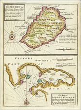
Finely executed plan of the Harbor and Fortress at Saint Helena, published by Nicolas Bellin. Located at the end of a deep valley, Jamestown is shown with a fort and several other buildings. An index in the upper left names six points of interest. The map marks stone paths carved into the side of the mountain in order to reach the island's large central plateau.
The map appeared in Bellin's monumental 5 volume Petit Atlas Maritime.
Jamestown and the Island of Saint Helena
The East India Company received a charter to govern Saint Helena from Oliver Cromwell in 1657, making Saint Helena one of Britain's earliest colonies in the eastern hemisphere. After the Restoration, the fort would be renamed after King James II, giving the island's capital its present name.
The 17th and early 18th century saw limited development of the island, with the population growing to 1,110 with common unrest and rebellion. At the time, the island's economy was driven by the thousands of ships that stopped each year at the island.
From about 1770, the island prospered, thanks to the attempts of governors to plant trees and undertake other betterment projects. In 1771, Captain Cook's Endeavour would stop at Saint Helena upon its return from the east coast of Australia.
Jacques-Nicolas Bellin (1703-1772) was among the most important mapmakers of the eighteenth century. In 1721, at only the age of 18, he was appointed Hydrographer to the French Navy. In August 1741, he became the first Ingénieur de la Marine of the Dépôt des cartes et plans de la Marine (the French Hydrographic Office) and was named Official Hydrographer of the French King.
During his term as Official Hydrographer, the Dépôt was the one of the most active centers for the production of sea charts and maps in Europe. Their output included a folio-format sea atlas of France, the Neptune Francois. He also produced a number of sea atlases of the world, including the Atlas Maritime and the Hydrographie Francaise. These gained fame and distinction all over Europe and were republished throughout the eighteenth and even in the nineteenth century.
Bellin also produced smaller format maps such as the 1764 Petit Atlas Maritime, containing 580 finely-detailed charts. He also contributed a number of maps for the 15-volume Histoire Generale des Voyages of Antoine François Prévost.
Bellin set a very high standard of workmanship and accuracy, cementing France's leading role in European cartography and geography during this period. Many of his maps were copied by other mapmakers across the continent.
![[ Atlas of England & Wales ] Geographiae Blauianae Volumen Quintum, quo Anglia, quae est Europae liber undecimus, continentur](https://storage.googleapis.com/raremaps/img/small/99196.jpg)
![(Angra, Madera, Azores, North Africa) De Cust van Barbaryen van out Mamora tot Capo Blanco [with] De Cust van Barbaryen van Capo Blanco Tot Capo de Geer [with] De Reede van Punte del Gada int Eylandt S. Michiels [with] De zuydhoec vant Eylandt Fayal [with] De Reede voor de Stadt Angra int eylandt Tercera [with] De Eylanden van Madera en Porto Santo](https://storage.googleapis.com/raremaps/img/small/83722.jpg)