


|
||

|

|
|

|
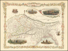
A striking full-color example of this marvelous map of the northern part of India. The area shown encompasses present-day northeastern India, Bangladesh, Bhutan, and Nepal. The map includes vignettes of life during the Company Raj as well as other decorations.
The map includes all major features from the area, including rivers, cities, and geopolitical boundaries. British-administered territories, namely Bangladesh, the area around Delhi, and other small holdings appear to be shown in pink, while areas controlled by Hindu leaders are shown in yellow. Other important states in the region are demarcated in green, while areas outside the region are uncolored and given minimal detail, including Tibet, Burma, and Lahore. The borders with Tibet are loosely defined, notably, Sikkim is not attributed to any nation. Calcutta and Fort William are still the administrative center for the British territories.
The map includes vignettes of The British Residency in Hyderabad, the ruins of Old Delhi, and also the coat of arms of the British East India Company. The vignettes are interesting as they display both imagery of colonial and traditional power; a Residency is displayed adjacent to a Juggernaut Car.
This map was engraved for R. Montgomery Martin's Illustrated Atlas. Tallis was one of the last great decorative map makers and his maps are prized for the wonderful vignettes of indigenous scenes, people, and more.
John Tallis (1817-1876) was a British map publisher. Born in the Midlands, Tallis came to London in the 1840s. Tallis began his London career with a series of remarkable London street views. He began a partnership with a Frederick Tallis, possibly his brother, but their collaboration ended in 1849. For the Great Exhibition of 1851, Tallis published the Illustrated World Atlas, one of the last series of decorative world maps ever produced. The maps were engraved by John Rapkin, a skilled artisan. The maps were later reissued by the London Printing & Publishing Company, who left the Tallis imprint intact, thus ensuring his enduring fame. In 1858, he began publication of the popular Illustrated News of the World and National Portrait Gallery of Eminent Personages, selling it in 1861 (it ceased publication in 1863).

![[Puducherry-- Hand Drawn Map] Plan de la Ville de Pondichery. Legende des Rues de la ville blanche et de la ville noire de Pondichery avec les numeros d'ordre correspondant a ceux du plan que Mr. le Gouvernor a approuve le Mai 1856](https://storage.googleapis.com/raremaps/img/small/58607.jpg)
![Colonel Mordaunt's Cock Match at Lucknow [Key Image]](https://storage.googleapis.com/raremaps/img/small/86563.jpg)