This item has been sold, but you can enter your email address to be notified if another example becomes available.


|
||

|

|
|

|
Stock# 77010
Description
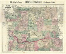
Wonderful vintage pictorial map of Pacific Coast of the United States, showing the routes covered by Southern Pacific Lines.
The map includes vignette illustrations of important points of interest on the West Coast, with particular attention paid to the old Spanish Missions.
The artwork for the map was done by W.H. Bull who produced maps very much in the characteristic West Coast style of the time, with stylized realism rendering topography and ground cover as if one was looking down on the area from 100,000 feet. In so doing, artists such as Bull blurred the lines between map and bird's-eye view.
The map is very much redolent of another maker from this time, Fred Routledge.
Condition Description
Folding map, printed on front and back.
![Map of Oregon Territory. By Samuel Parker. 1838. [with:] Journal of an Exploring Tour Beyond the Rocky Mountains, under the direction of the A. B. C. F. M. 1840.](https://storage.googleapis.com/raremaps/img/small/97939.jpg)