|
||

|

|
|

|
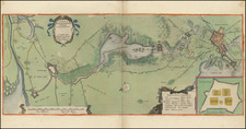
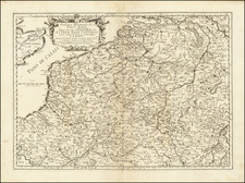
Attractive original antique map showing the area surrounding the important Dutch port city of Rotterdam. The map centers on the Meuse River, with the city at the time of this map's creation occupying only the north bank of the river. This map originally appeared in Bellin's Le Petit Atlas Maritime.
This map was made for navigational purposes and shows soundings and sandbars in the river. The map also shows the separate town of "Delfs-haven," which has now become a neighborhood of the city known for its older buildings as it was largely spared from WWII destruction.
Jacques-Nicolas Bellin (1703-1772) was among the most important mapmakers of the eighteenth century. In 1721, at only the age of 18, he was appointed Hydrographer to the French Navy. In August 1741, he became the first Ingénieur de la Marine of the Dépôt des cartes et plans de la Marine (the French Hydrographic Office) and was named Official Hydrographer of the French King.
During his term as Official Hydrographer, the Dépôt was the one of the most active centers for the production of sea charts and maps in Europe. Their output included a folio-format sea atlas of France, the Neptune Francois. He also produced a number of sea atlases of the world, including the Atlas Maritime and the Hydrographie Francaise. These gained fame and distinction all over Europe and were republished throughout the eighteenth and even in the nineteenth century.
Bellin also produced smaller format maps such as the 1764 Petit Atlas Maritime, containing 580 finely-detailed charts. He also contributed a number of maps for the 15-volume Histoire Generale des Voyages of Antoine François Prévost.
Bellin set a very high standard of workmanship and accuracy, cementing France's leading role in European cartography and geography during this period. Many of his maps were copied by other mapmakers across the continent.