This item has been sold, but you can enter your email address to be notified if another example becomes available.


|
||

|

|
|

|
Stock# 77002
Description
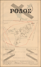
Attractive map showing the port of Nafplion on the Peloponnese. The map centers on the Argolic Gulf and names numerous towns and features in the area. The towns of Nafplion and Argos are shown to be located on hills above the bay.
Nafplion first rose to prominence during Byzantine and Frankish rule, when it was captured by French troops during the Fourth Crusade. It would later come under Venetian and then Ottoman rule and was a major Ottoman stronghold during the Greek War of Independence. Today, it is an attractive coastal town that draws visitors from the world over.
Rarity
The charts from Heather's New Mediterranean Pilot . . . are extremely rare on the market. This is the first example of this chart we have ever seen.
![[Kingdom of Crete, Santorini, etc.] Isle et Royaume de Candie, tiree de divers Memoires . . .](https://storage.googleapis.com/raremaps/img/small/98170.jpg)