


|
||

|

|
|

|
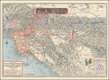
Oil Speculation in the Salinas Valley
Extremely rare oil speculation map of the area in Northern San Luis Obispo County and Southern Monterey County, showing prospective oil districts around the towns of Paso Robles and San Miguel, California in 1901.
This locally published map shows several (dubiously identified) oil districts. The creation of the map is described in the San Luis Obispo Tribune on December 9, 1900, noting that
C. L. Wright went to Salinas Thursday to obtain some important data in reference to the map of Northern San Luis Obispo and Southern Monterey counties which is now under way. He expects to have the maps out about January 1st. (referencing an article in the San Miguel Messenger).
While there seems to have been some modest efforts at drilling in the area, curiously, the names "Paso Robles Oil District" and "San Miguel Oil District" seem to be non-existent, other than as named in this map. We note that there are over 10 different oil companies located on the map, including:
- Acme Oil Company
- Paso Robles Oil & Drilling Company
- Monterey Oil Company
- Nacimiento Oil Company
- GH Oil Company
- Colorado Oil Company
- Safe Oil Company
- Safe & Puritan Oil Company
- San Miguel Land & Oil Company
- Red Bank Oil Company
The Nacimeiento Oil Company, San Miguel Oil Company and Safe Oil Company were actively drilling several hundreds miles south of this area in the Newhall area of Los Angeles County, but otherwise there does not seem to be much historical information suggesting active oil drilling in the region. A 1904 Water Resources report written by Homer Hamlin and published by the U.S. Geological Survey references a failed oil well drilled by the Monterey Oil Company southwest of Bradley, California, in the general vicinity of the town of San Miguel, which was a failure. At page 19 of the report, the author notes that "erroneous theories are entertained by some oil men and investors regarding the oil-producing formations in California," going on to note that in trying to drill in these regions, "it is very probable that the drill has reached the Monterey shale, and further exploitation will doubtless result in disappointment."
The main map shows the Salinas Valley from Carissa Plain to San Lucas, with railroads, rivers, cities, and more shown. The map is subdivided into townships and tracts. The main map is flanked by two maps showing the Paso Robles Oil District and the San Miguel Oil District, with a further inset showing the state with all its railroads and other major oil districts. Two vignettes show the Paso Robles Hotel and the San Miguel Mission. The Oil District maps note significant drilling activity, with numerous drilling companies located.
While it is possible that there was activity search for oil in these regions, as noted by Hamlin, the area would not have been productive. The nearest successful oil fields would have been roughly 30 to 50 miles northest of Cholame Creek (shown on the San Miguel Oil District Map), where the Cholame Oil Wells were being drilled south of the Coalinga Oil Field (see Hamlin map, between pages 10 and 11).
While the oil industry was booming in California during this period and the preceding decades, there were no meaningful discoveries in this part of California until the discovery of the San Ardo Oil Field (about 20 miles north of San Miguel) in 1947, which would go on to become the 13th largest oil field in California history.
Rarity
We trace only a single example of this map, at the Huntington Library.
We find no additional institutional examples or examples that have traded on the market.

![[Native American Indians in Southern California] Native Sites in Part of Southern California](https://storage.googleapis.com/raremaps/img/small/102006.jpg)