|
||

|

|
|

|
Updated Issue of the First Postal Road Map
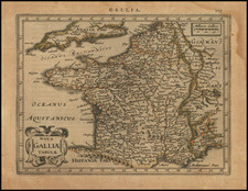
Significantly revised and improved 1679 edition of the first postal route map of France, originally published in 1632.
The first edition of the map was issued several years after France created the first national postal system with fixed rates and time schedules in 1627. The present edition was issued shortly after France became the first country to create a national postal system in 1672.
According to a Princeton University site on thematic maps :
This is the first postal road map -also the first important map issued by Sanson. The map shows all of the routes used by the royal posts of the time, identifying the stops along the way; it was reprinted many times during the seventeenth century. . . .
This updated state, while using the same copperplate as the first state, shows numerous improvements and updates. The post roads have been heavily developed, with more remote parts of the country (such as Brittany) now receiving their own post routes. In addition, national borders have been drawn in, and all the major regions of France are explicitly named. As in previous states, this map has a curious incursion into London, stopping by way of "Cantorbery."
The French Post
In 1477, Louis XI set up a Royal Postal Service, employing 230 mounted couriers, which was not intended for public use. The security and regularity of the service along certain routes, when compared to previous means of communication, inevitably resulted in an increasing amount of unofficial correspondence being carried. After initial attempts to prevent this practice, its fiscal advantages were realized, and private mailings were legalized in the early 17th Century. The basis of a real public service was not created until 1627, when fees and timetables were fixed and post offices established in the larger cities.
In 1672, France made postal services a controlled state monopoly. Previously granted private operators were allowed to continue, but over time they were forced out of business or acquired by the state. In 1719 the University of Paris, the most important private competitor, gave up its last postal privileges in return for substantial compensation.
Nicholas Sanson (1600-1667) is considered the father of French cartography in its golden age from the mid-seventeenth century to the mid-eighteenth. Over the course of his career he produced over 300 maps; they are known for their clean style and extensive research. Sanson was largely responsible for beginning the shift of cartographic production and excellence from Amsterdam to Paris in the later-seventeenth century.
Sanson was born in Abbeville in Picardy. He made his first map at age twenty, a wall map of ancient Gaul. Upon moving to Paris, he gained the attention of Cardinal Richelieu, who made an introduction of Sanson to King Louis XIII. This led to Sanson's tutoring of the king and the granting of the title ingenieur-geographe du roi.
His success can be chalked up to his geographic and research skills, but also to his partnership with Pierre Mariette. Early in his career, Sanson worked primarily with the publisher Melchior Tavernier. Mariette purchased Tavernier’s business in 1644. Sanson worked with Mariette until 1657, when the latter died. Mariette’s son, also Pierre, helped to publish the Cartes générales de toutes les parties du monde (1658), Sanson' atlas and the first French world atlas.
![Gallia Narbonens [on sheet with] Savaudiae Ducat. [on sheet with] Venuxini Comitatus Descr.](https://storage.googleapis.com/raremaps/img/small/61471.jpg)
![(Atlas of France) Les Cartes Generales de Toutes les Provinces de France Reveues corrigees & augmentees par le Sr. Tassin Geographe ordinaire de sa Mageste [The General Maps of All the Provinces of France, Reviewed, Corrected, and Expanded by Mr. Tassin, Geographer to His Majesty.]](https://storage.googleapis.com/raremaps/img/small/95902.jpg)