


|
||

|

|
|

|
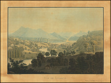
Ski Map of the Davos Area Published in the Mid-1950s
Attractive map of the skiing around Davos, Switzerland. The map shows the many ski runs to be explored in the area, both "downruns" and ascents. An index at the bottom of the map denotes the names of each run alongside its relative difficulty.
The map is attractive, showing pictorial trees as well as skiers enjoying the mountain. The famous resort towns of the area are all named, including the Davos-Platz and Davos-Dorf towns, and the many high-altitude chalets are shown. Adjacent to the map and on the verso of the map are a number of attractive color photographs and sketches of Davos.
This map includes a mention of the "Cable Airway Parsenn" that opened in 1955; otherwise, features on the map are identical to other dated 1950s maps of the ski area. thus providing an approximate date range for the map.
Herbert Leupin produced a series of ski posters for Davos, all dating from the 1940s and 1950s. One of these 1950s posters is reproduced on the front cover of the map. Leupin's posters are highly desirable today, but we find no other record of his artwork appearing alongside a Davos map.
![[ Zurich Region / Switzerland ] Delineatio Pagi Tigurini ex observationibus recentissimis et accuratissimis Accedit serosim in tabella Dominium Sax et Forsteck . . .](https://storage.googleapis.com/raremaps/img/small/103389.jpg)
![[ Valais Canton ] Das ober Wallisserlandt | Wallisser landt wie du sichst. . .](https://storage.googleapis.com/raremaps/img/small/95847.jpg)
![[Switzerland] Charte de la Suisse, de la Rhetie, ou des Grisons, de la Valtelin, du Valay, & autres Seigneuries Voisines Exactement dressee sur les Lieux par Gaspr Baudouin Ingenieur Militaire & Capitaine de l'artillerie du Roy . . . en L'Estat de Millan](https://storage.googleapis.com/raremaps/img/small/91530.jpg)