


|
||

|

|
|

|
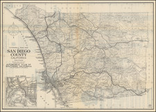
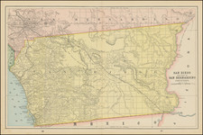
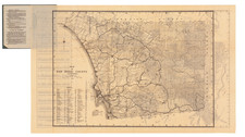
Very scarce vintage map of Solana Beach, San Diego. This cadastral map shows allotments between the Pacific Ocean and San Dieguito Park (already labeled) and provides a fascinating look at the early layout of the neighborhood.
The map is dated to c. 1952 as it shows San Dieguito Park and names Eden Gardens, rather than La Colonia, a name that had been frequently switched around. Numerous parcels of land are shown, and roads and neighborhoods are named. In all, the map is highly detailed and cadastral.
The map was issued by the Lumber and Builders Supply Company and based on a map provided by the local Chamber of Commerce. The Lumber and Builders supply company used to stand at the corner of Lomas Santa Fe and North Cedros (near the Amtrak station), and its yards used to take up the whole block heading northwards towards E Cliff Street. It was known that the company was already in need of maps as early as 1929, when they wrote to Ed Fletcher, a local businessman turned politician, to request six of the maps that he had issued.

![[ Ocean Beach / Point Loma ] Map of Point Loma Electric Railway](https://storage.googleapis.com/raremaps/img/small/96377.jpg)