


|
||

|

|
|

|
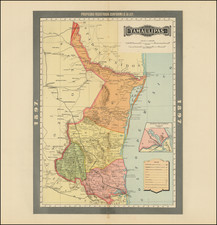
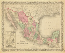
Post-Gadsden Purchase Border
Very detailed map of Mexico, published by GW & CB Colton in New York.
The map shows towns, counties, Gulf of Mexico and Gulf of California, etc., with lovely decorative border and inset of Territory and Isthmus of Tehuantepec.
The areas immediately north of the border in the regions acquired in the Gadsden Purchase are described as:
Desert (Uninhabited) Isolated Mountains, without grass wood or water. Vegetation chapparal and catci.
G. W. & C. B. Colton was a prominent family firm of mapmakers who were leaders in the American map trade in the nineteenth century. The business was founded by Joseph Hutchins Colton (1800-1893) who bought copyrights to existing maps and oversaw their production. By the 1850s, their output had expanded to include original maps, guidebooks, atlases, and railroad maps. Joseph was succeeded by his sons, George Woolworth (1827-1901) and Charles B. Colton (1831-1916). The firm was renamed G. W. & C. B. Colton as a result. George is thought responsible for their best-known work, the General Atlas, originally published under that title in 1857. In 1898, the brothers merged their business and the firm became Colton, Ohman, & Co., which operated until 1901, when August R. Ohman took on the business alone and dropped the Colton name.
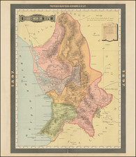
![[Arizona below New Mexico] Mexique d'apres le grand Atlas Dresse Par A.H. Dufour Grave par ch Dyonet Pubie par A. Le Chevalier . . . 1863](https://storage.googleapis.com/raremaps/img/small/64395.jpg)