


|
||

|

|
|

|
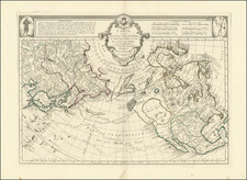
Scarce map of North America, published shortly after Mexico declared its independence from Spain.
This is a rare early edition of the map, pre-dating the first charting of the Arctic Coastline in the western part of the Canadian Arctic.
This map also includes significant revisions in British Columbia attributable to the explorations and discoveries made by the Northwest Company and Hudson's Bay Company in the region.
The map is remarkably detailed, especially in the West. Texas is not yet named. Northwest of Texas, there is a significant amount of Indian and topographical details, more so than on most maps of the period. Oregon Territory includes the details from Lewis & Clark, the Astorians, and other early explorations in the region, along with lots of Indian details.
The map includes fine detail in Neu (Upper) California, including the Missions, mythical rivers, but pre-dates the 1834 appearance of Russian Settlements near San Francisco on the map. Highly details NW Coast of America, including American, British and Russian settlements and forts, Indian Tribes, etc. Nice detail in Alaska, which is called "Nordlicher Polar Kreis." Massive Northwest and Missouri Territories shown.
The Rocky Mountains extend north nearly Mackenzie River.
The coastline of Alaska is also significantly improved along the northern coastline, providing final details to a region which was uncharted on the 1834 edition of the map.
Rarity
Weiland's maps are quite scarce, this being the first example we have handled of this 1826 edition.
![[An English Propaganda Map In French] Carte Des Possessions Angloises & Francoises Du Continent De L'Amerique Septentrionale 1755.](https://storage.googleapis.com/raremaps/img/small/86975.jpg)
![[ First Map to Name The United States ] L'Amerique septentrionale ou se remarquent les Etats Unis . . . 1779](https://storage.googleapis.com/raremaps/img/small/94192.jpg)