|
||

|

|
|

|
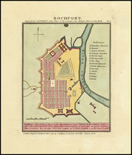
Attractive town plan of Rochfort, in southwest France. The city sits on the Charente River close to the river's outflow in the Bay of Biscay. The map shows the layout of the town, enumerating important buildings and places. The town is unusual in that it is a 17th-century "ville nouvelle," built by the orders of Jean-Baptiste Colbert during the reign of Louis XIV. It served as a resupply center for the French Navy and would be raided by the British during the Seven Years War.
Luffman's Select Plans is an uncommon traveler's guide that served to educate the intrepid traveler regarding any part of the world, from the major cities of Europe to the wild coasts of the Spice Islands. Each of Luffman's maps contained detailed coastal descriptions showing the major landmarks and cities, as well as basic but necessary navigational information. This plate appeared in the first of Luffman's two volumes.
![[Biscaya] De Zeecusten van Vrancrijck en Biscaijen tuschen Arcachon en de C. de Machicaco](https://storage.googleapis.com/raremaps/img/small/84355.jpg)