
This item has been sold, but you can enter your email address to be notified if another example becomes available.


|
||

|

|
|

|
Stock# 76794
Description
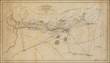
With View of Austin on Verso
Rare Houston & Texas Central Railroad map of Texas and Indian Territory, printed by Rand McNally & Company in Chicago.
The map shows railroads in operations, projected railroads, stage lines, Government Telegraph Lines and Mail Routes.
The map focuses on the land holdings of the Houston & Texas Central Railroad which are "Sectionized into 640 Acre Squares" and highlighted in green overprinting.
The map shows sections located in green showing the "Mineral District" and "Grazing District," along with a massive "Cotton and Grain District".
All of Indian Territory is included, with the panhandle already separate and labeled Public Lands.
Condition Description
Minor loss along folds.
![[ Texas-Mexico Border Treaty ] Que á efecto de facilitar el cumplimienio [i.e. cumplimiento] del art. 3. del Tratado de limites entre estos Estados y los Unidos del Norte América ... Habiéndose concluido y firmado en la Ciudad de México á los 12 dias del mes de Enero de 1828, un tratado entre los Estados-Unidos Mexicanos y los Estados-Unidos de América [A Treaty having been concluded and signed in the City of Mexico on the 12 day of January 1828 between the United States of America and the Mexican United States for the purpose of establishing the true dividing line and boundary between the two nations]](https://storage.googleapis.com/raremaps/img/small/100806.jpg)
![[ Colorado ] [ Indian Territory on verso ]](https://storage.googleapis.com/raremaps/img/small/101102.jpg)