This item has been sold, but you can enter your email address to be notified if another example becomes available.


|
||

|

|
|

|
Stock# 7679
Description
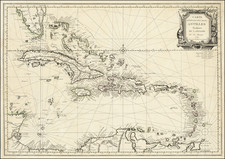
Detailed map of the Gulf Coast, Caribbean and Central America, extending north to South Carolina. Nice example of Florida as a narrow archipelago on the French model, in contrast to the wider projections in English maps. The Bahamas are shown in great detail, as is the entire Caribbean. Nice detail throughout central America. Fort Louis in Texas is shown. A number of forts showin along the Gulf Coast. The difference in cartographic styles between the French and English are well illustrated by comparison of contemporary maps of this period.