|
||

|

|
|

|
Stock# 76786
Description
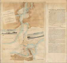
Interesting map of a portion of New Jersey and Manhattan focused on the water supply to the New Jersey suburbs of New York City.
The map shows a number of proposed aqueduct lines running through New Jersey, terminating in Hoboken with what seems to be a proposal to send water under the Hudson River to Manhattan.
Supplying water to New York City and the adjacent communities in New Jersey had long been a task for local civil engineers. Large aqueducts and reservoirs were constructed to bring water from the Adirondacks and elsewhere into the metropolitan area.
Spielmann & Brush were Hoboken-based mapmakers who produced most of their output in the 1870s and 1880s.
The map is oriented with west at the top.
Condition Description
Minor discoloration along folds.
![[Manhattan / Lower East Side]](https://storage.googleapis.com/raremaps/img/small/59559.jpg)
![[Long Island City - Blackwell's Island Bridge]](https://storage.googleapis.com/raremaps/img/small/59904.jpg)
![[ Charleston, Boston, New York, St. Augustine, Bahamas, etc ] Particular Draughts of some of the Principal Towns and Harbours belonging to the English French and Spanish in America and the West Indies.](https://storage.googleapis.com/raremaps/img/small/102804.jpg)