|
||

|

|
|

|
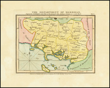
Attractive original plan of the French department of Morbihan, in southern Brittany.
The region draws its name from the large bay in the center of the department's coastline, the Morbihan, on which sits the administrative center of Vannes. The offshore islands of Belle Isle, Hoedic Isle, and Hoat Isle are named. Other parts of Brittany, as well as part of the Pays de la Loire, are also shown. The detail is extensive, including many towns, cities, roads, and more.
Luffman's Select Plans is an uncommon traveler's guide that served to educate the intrepid traveler regarding any part of the world, from the major cities of Europe to the wild coasts of the Spice Islands. Each of Luffman's maps contained detailed coastal descriptions showing the major landmarks and cities, as well as basic but necessary navigational information. This plate appeared in the first of Luffman's two volumes.

![(Seven Years' War) [Large contemporary British manuscript plan of the Bay and Battle of Quiberon]](https://storage.googleapis.com/raremaps/img/small/103273.jpg)