|
||

|

|
|

|
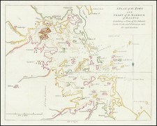
Earliest Obtainable Separate Map of Nantucket
French edition of the earliest separate map of Nantucket, published in the 18th century. Originally prepared to accompany Michel Guillaume St. Jean de Crevecoeur's Lettre d'un Cultivateur Americain (Letters from an American Farmer), the map shows the island of Nantucket as well as the nearby island of Tuckernuck.
The map includes a key naming 32 landmarks and a decorative compass rose. Several additional places are named directly on the map. The town of Sherburne, which would be renamed after the island in 1795, is shown with several small houses and mills. Fulling Mill, which now names a road east of its original location, is also named. A sandbar off the island's southeastern tip is named Pochick.
Letters from an American Farmer
The epistolary novel Letters from an American Farmer, published by the French immigrant St. Jean de Crevecoeur, describes the lifestyle of farming on the island of Nantucket in the period immediately preceding the Revolutionary War. Written from the point of view of someone corresponding with an English gentleman, the book was only moderately popular in the US but proved a success in Europe, so much so that it is credited with spurring a wave of French migration.
Several of the work's letters deal with the island of Nantucket, describing the politics and customs of the island, focusing on its Quaker society.
Publication History
The map was engraved by Tardieu in 1785, but was not published until 1787, alongside a later edition of Crevecoeur's Lettre d'un Cultivateur Americain. The presented map is based on a similar map that appeared alongside the 1783 English Letters of an American Farmer, the latter of which is exceedingly rare.
![[Plymouth Bay, Cape Cod Bay, Duxbury Bay]](https://storage.googleapis.com/raremaps/img/small/51249.jpg)