|
||

|

|
|

|
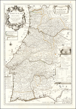
Portugal in the Final Years of the Sixteenth Century
Rare and early map of Portugal, published in Cologne by Johannes Matalius Metellus, also known as Jean Matal. Matal’s cartographic works are quite rare and are seldom seen on the market.
The west-oriented map shows Portugal split into bishoprics by dotted lines. A strapwork cartouche carries the title in Latin and Portuguese, while a large sailing vessel decorates the Atlantic Ocean.
The present map is one of several maps of Portugal published in the sixteenth century based on a lost manuscript drawn in 1560 by Fernando Alvaro Seco. The original manuscript map of Alvaro Seco was taken to Rome and given as a diplomatic gift to the Holy See following the installation of Pope Pius IV in January 1560. It was carried to Rome by the Portuguese humanist and writer Achilles Estaço, who served as librarian to Cardinal Guido Sforza and as secretary to Pope Pius IV.
The Alvaro Seco map was perhaps the single most important and influential map of Portugal of the sixteenth century. It continued to be the basis of maps of Portugal in manuscript and printed forms until the appearance of Pedro Teixeira Albernaz’s map of 1662—nearly a full century later.
As noted by Alegria et al.:
The well-known map of Fernando Álvaro Seco is known through rare impressions of two versions. One was engraved by Sebastiano di Re, published by Michele Tramezzino with papal and Venetian senatorial privilege, and printed in Venice sometime after 1561. The other was engraved by Joannes van Doetecum, published by Gerard de Jode in Antwerp, and dated 1565. Both were dedicated to Cardinal Sforza by a Portuguese humanist, Achilles Estaço….
The Seco map gained even more importance when a version of it appeared in Abraham Ortelius’s Theatrum orbis terrarium (1570). It also appeared in De Jode’s atlas, Speculum orbis terrarum (1578).
Cologne School
This work is from the so-called Cologne School of mapmaking, the members of which made a concerted, though largely unsuccessful, attempt to supplant Antwerp (and to a lesser extent Amsterdam) as a mapmaking hub in the 1590s and first decades of the seventeenth century. Cologne's role as a mapmaking center was boosted by Dutch and Flemish refugees fleeing persecution and war, just as that of Amsterdam was boosted by those leaving Spanish-controlled Antwerp after 1588.
Rarity
Metellus's maps are very rare on the market. This is the first time we have handled this map and we find no examples of this 1598 issue in any standard map databases.
Johannes Matalius Metellus, also known as Jean Matal or Johannes Metellus Sequanas, was born in Poligny, Burgundy, France in ca. 1517. A humanist scholar, he was a polymath devoted to cartography, geography, law, paleography, and antiquarianism. Late in life he published a series of atlases; all his maps and atlases are rare and highly sought-after.
Matal was educated at Dole, Freiburg, and several Italian institutions. At Bologna, he met Antonio Agustín, a Spanish legal scholar, who recruited Matal to be his secretary. Together, the men researched ecclesiastical law, with an especial emphasis on Roman legal manuscripts, with trips to Venice, Florence, and elsewhere in Italy to study codices. In 1555, the two traveled to England to meet with Queen Mary on a mission for the Church.
After leaving his employment with Agustín, Matal traveled in the Low Countries and eventually settled in Cologne. There, he mixed with other savants, including especially Georg Cassander and Pedro Ximénez. It was in Cologne that Matal began his serious interest in mapmaking. He contributed to Braun and Hogenberg’s Civitae Orbis Terrarum; Georg Braun described him in glowing terms, “vir omni scientiarum genere praestans"—"a man outstanding in every form of knowledge."
Late in life, Matal began preparing a set of maps of the entire world. In 1594, he published an atlas of France, Austria, and Switzerland (39 maps), in 1595 an atlas of Spain (10 maps), and, posthumously, an atlas of Italy (37 maps), and one of Germany and the Netherlands (55 maps). Many of these maps were combined and augmented into atlases of Europe, Asia, Africa, the Americas, and the world’s islands. In 1602, a compendium work showcased all of these previous works called Speculum Orbis Terrae; this atlas was well received by contemporaries like Walter Raleigh and is very rare today. Many of these maps and atlases were released after his death in 1598, they were finished by his friend and fellow mapmaker Conrad Loew (Matthias Quad).
![[T erceira ] Circuito da Ilha Terceira, dividido em 8 Districtos Militares, forca de cada um, e os lugares accessi veis, os quars sao indicados com o signal, *' assim as pecas com a letra p](https://storage.googleapis.com/raremaps/img/small/77790.jpg)
![Oporto [Porto]](https://storage.googleapis.com/raremaps/img/small/83573.jpg)
![[Azores] Carta Reducida y General de Las Islas de los Azores . . . 1781 [east sheet]](https://storage.googleapis.com/raremaps/img/small/93245.jpg)