


|
||

|

|
|

|
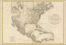
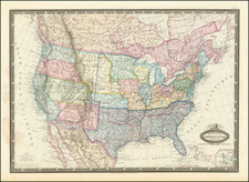
Showing The Discoveries of Lewis & Clark and "Supposed River ... which will probably be the communication between the Atlantic and Pacific"
Very early coast to coast map of the United States, engraved in New Haven, Connecticut by Alfred Daggett.
The map is one of the first American maps to exhibit the fulfillment of Thomas Jefferson's image of American Manifest Destiny, the US extending from the Pacific to the Atlantic. The map was issued shortly after the Adams-Onis Treaty of 1819 and the admission of Missouri as a state in 1820, with the boundary of the newly minted state of Missouri shown in a highly inaccurate fashion. The remainder of the Louisiana Purchase is identified as "Missouri Territory."
Perhaps the most remarkable feature of the map is the depiction of the mythical River Buenaventura (derived from the Escalante-Dominguez Expedition of 1776 -- see below), extending from the Rocky Mountains to an unnamed Lake (Salt Lake) and then tentatively on to San Francisco, noting that it "will probably be the communication (by water) "between the Atlantic and the Pacific." Coming after the conclusion of the Lewis & Clark explorations, this bold statement is one of the last appearances of a suggestion that there still remained the prospect for crossing the country by water. In this instances, the map seems to suggest that the sources of the Platte River in the Rocky Mountains might yield an as yet undiscovered portage to the headwaters of the Rio Buenaventura.
The map also teases a similar conclusion for a connection via one of the upper tributaries of the Colorado River, most likely the Rio Zaquananas (Zaguananas). The river name comes from the map of Bernardo Miera y Pacheco, drawn during the 1776 expedition of Spanish friars Silvestre Vélez de Escalante and Francisco Atanasio Domínguez, who also named the Rio Buenaventura. Miera's map erroneously indicated that the Rio Buenaventura flowed southwest to what is now known as Sevier Lake (Utah). Later cartographers extended the error, representing the Buenaventura River as flowing into the Pacific Ocean.
The Zaguanas River was one of the sources for the modern day Green River. While it was known that the Green River drained to the Colorado, the exact course was not known. Miera's map showed the Colorado River branching into two major streams – the Nabajoo (San Juan) and the Zaguananas. It also showed the Zaguananas branching into four heads, including the Dolores and the Rafael, one of which is the unnamed river shown here penetrating deep into the Rocky Mountains and nearly to the Rio Grande.

![[ Early United States ] Etats Unis De L'Amerique](https://storage.googleapis.com/raremaps/img/small/98746.jpg)