


|
||

|

|
|

|
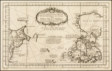
Earliest Detailed Map of Sitka Sound
The first high-resolution map of Sitka Sound and the first to attempt to use Tlingit toponyms, it dates to the period immediately prior to Sitka's settlement by the Russian American Company in 1799.
The map was published as part of the 1790-2 voyage account of the Solide Expedition edited by Charles Pierre Claret de Fleurieu and which drew on materials from Captain Prosper Chanal, surgeon Claude Roblet, and merchant and navigator Étienne Marchand.
The map shows the outline of the bay and island with sounding depths, sandbars, and navigational obstructions. The shoreline is relatively complete, but there are unfinished junctures—a reflection of the still nascent European geographic knowledge of the area.
An important feature is Montaña San Jacinto, today known as Mount Edgecumbe. This was named initially by Juan Francisco de la Bodega y Quadra after Saint Hyacinth, whose saint day followed the date Bodega y Quadra saw the mountain, August 16, 1775. James Cook later renamed it on May 2, 1778 as Mount Edgecumbe; he either named it after the estate near Plymouth Harbor or George, the first Earl of Edgecumbe.
Early European encounters with Sitka, Alaska
The area where Sitka now sits has been inhabited by Tlingit peoples for thousands of years. It first came to European attention with the 1775 expedition of Juan Francisco de la Bodega y Quadra. Worried that the British, French, and Russians might eclipse their Pacific influence, the Spanish reinvigorated their Pacific Northwest exploratory expeditions in 1774. Juan Pérez in the Santiago sailed to the southern tip of Vancouver Island, then thought to be part of the mainland. However, he never landed or formally claimed land on behalf of Spain and turned back at Haida Gwaii.
A year later, Bruno de Heceta commanded a second expedition in the Santiago. He followed Pérez’s route north, in company with the Sonora and the San Carlos. The Sonora was a small schooner intended to be able to get close to the shore for charting and surveying. This hydrographic vessel was commanded by Bodega y Quadra.
After the Santiago and the San Carlos turned back, Bodega y Quadra, now alone, took the Sonora to 59°N latitude. He sailed into Sitka Sound, claiming the land in the name of the Spanish Crown. Bodega y Quadra named the Sound Guadalupe Bay, as indicated in the map’s title block.
The place was next visited by Captain James Cook on his third Pacific expedition, this time in search of the Northwest Passage. Arriving in the area in May 1778, he called it Norfolk Sound.
The Solide Expedition
Although relatively little-known today, the voyage led by Étienne Marchand was the second French circumnavigation of the world. The first had been completed by Louis-Antoine de Bougainville from 1776-1779; his was also the second European ship to visit Tahiti. Marchand was also the first Frenchman to make a commercial expedition to what is now British Columbia and Alaska; he followed his countryman La Perouse to the area (1786), although La Perouse’s doomed voyage was a government-sponsored exploratory expedition.
Marchand was born in Grenada in 1755, part of France’s sprawling imperial diaspora. In 1789, while at St. Helena, Marchand—a merchant and navigator—struck up an acquaintance with Nathaniel Portlock. Portlock had served as a master’s mate on James Cook’s third expedition. Impressed by the quality and quantity of furs the crew encountered in the Pacific Northwest and sold in China, Portlock and several partners started the King George’s Sound Company to expand this trade. In 1785, Portlock and fellow third-voyage alum George Dixon led the King George and Queen Charlotte on a three-year trading voyage in the Pacific.
Portlock and Dixon published an account of their voyage, as well as spoke of it to curious merchants like Marchand. When back in France, Marchand ordered a new ship, the 300-ton Solide, to be built in Marseilles. He sailed in December of 1790 with ship’s surgeon Claude Roblet and Captain Prosper Chanal, Marchand’s second-in-command.
They made for the northern Pacific, where they began to trade with Tlingit peoples for pelts. However, they had to leave the Sitka area after they witnessed what they thought were signs of smallpox. The ship sailed south, working amongst the Queen Charlotte Islands. They arrived on Vancouver Island on August 4, 1791. Then then set out for Hawai’i on September 8, 1791. En route, Captain Robert Gray of the Columbia Rediviva spotted the Solide, although the two ships did not meet.
After Hawai’i, Marchand sought Chinese fur markets in Macao, only to find that the Chinese were not interested. Disappointed, the Solide struck out for the Île de France (Mauritius), where they arrived in late January 1792. They stayed for eleven weeks before sailing for France. They arrived in Toulon on August 14, 1792 having lost only one man, to a stroke. However, Marchand also arrived with a full cargo of furs. His company sent them to Lyons, where the Revolutionary Government impounded them. They rotted in warehouses in the port city.
Marchand sailed again almost immediately, but he died on Reunion Island on May 15, 1793. His voyage was not overlooked, however. It had caught the attention of Charles Pierre Claret de Fleurieu. Fleurieu had previously served as Louis XVI’s Ministre de la Marine et des Colonies; he later served as the governor of the Dauphin. During the Terror, he and his wife served fourteen months in prison and had their assets dispersed. After the fall of Robespierre, Fleurieu was returned to a modicum of his former station, joining the Bureau des longitudes in 1795 and becoming a prominent politician again.
In between these events, he was also editing the journals of the Solide expedition. He combined the journals of Chanal and Roblet, among others, to produce a four-volume account published from years VI-VIII (1798-1800). The work contained a variety of original maps, as well as important ethnographic information about the Tlingit peoples. The account was translated into English in 1801.

![[Map of Russian Possessions in North America] Карта Российскаго Владѣнія въ Сѣверной Америкѣ](https://storage.googleapis.com/raremaps/img/small/66569.jpg)