|
||

|

|
|

|
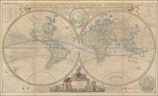
Rare Late State of John Melish's Rare World Map
Good example of this rare late state of John Melish's rare map of the World on Mercator's Projection, first published in Philadelphia.
Melish's map of the World is one of the earliest wall maps of the world printed in America. The present example is significantly updated and improved. The title has been moved to the right, in order to accommodate a depiction of the newly discovered lands in Antarctica. The map tracks the discoveries of Fabian Gottlieb von Bellingshausen (1819-1820), James Weddel (1819-24) John Biscoe (1830-1833), James Clark Ross (1839-1843) and Charles Wilkes of the United States Exploring Expedition (1840) through the Antarctic Region, establishing some of the earliest discoveries in the south polar regions.
The map also reflects the significant advances known in the Arctic regions between 1819 and the 1840s, although final confirmation of the Northwest Passage was still a decade away.
A massive pre-statehood Texas is shown, with Upper California shaded as part of the US, although the Mexican War had just begun.
Melish's World Map
John Melish, who is best known for his hugely important map of the United States, was also responsible for a large world map published in 1817. See the Library of Congress copy of the Melish world map. We have been unable to identify any recorded editions of the Melish world map between its publication between about 1817 and 1820 by Melish, and this edition of the map. It seems likely that the plates passed to Finlayson in 1823, and then possible R. L. Wilson by the 1830s. Later, the plates would again be utilized by Lucious Stebbins in an addition dated 1859.
While there have been quite a few changes to the copper plate, it is clear that both maps were printed from the same matrix; the latitude and longitude markers are largely unchanged, the cartouche, with its Putti, has been modified to remove the title, but it is largely unchanged. Northeast of "Hudson's Bay" there has been an imperfect erasure of "North Sleepers" and most of the word "North" can still be seen.
Rarity
The map is extremely rare. We note a single example of the 1845 edition at the Boston Public Library. This 1846 edition is apparently unrecorded.
John Melish (1771-1822) was the most prominent American mapmaker of his generation, even though his cartographic career lasted only a decade. Melish was born in Scotland; he moved to the West Indies in 1798 and then to the United States in 1806. By 1811, he had settled in Philadelphia and published Travels through the United States of America, in the years 1806 & 1807, and 1809, 1810, & 1811, which was richly illustrated with maps.
Melish created several regional maps of the highest quality, as well as the Military & Topographical Atlas of the United States (Philadelphia, 1813, expanded 1815). The latter work is widely considered to be the finest cartographic publication to come out of the War of 1812.
By far his best-known work is his monumental map of the United States of 1816, Map of the United States with the contiguous British and Spanish Possessions. He began working on the map in 1815 and sent it to Thomas Jefferson for comment in 1816. Jefferson enthusiastically reviewed the map and returned it with his edits. Jefferson later hung an example of the map in the Entrance Hall of Monticello and sent it to associates in Europe.
Melish’s finished product was the first map of the United States to extend to the Pacific Ocean. After its publication in 1816, Melish ensured the map was as up-to-date as possible; it was reissued in 25 known states published between 1816 and 1823. The map captured the then rapidly changing geography of the United States, as well as various boundary disputes, treaties, and expansion.
![[Volcanos and the Subterranean World] Tabula Geographico-Hydrographica Motus Oceani, Currentes, Abyssos, Montes Igniuomos In Universo Orbe Indicans, Notat Haec Fig. Abyssos Montes Vulcanios](https://storage.googleapis.com/raremaps/img/small/95720.jpg)