|
||

|

|
|

|
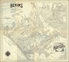
Felix Viole's First Map
Very rare early-20th-century map of Los Angeles, made by French born civil engineer and surveyor Felix Viole and published by John F. Spring.
This 1902 map is the first of Viole's of Los Angeles, which would be followed in 1904 by another map of Los Angeles and a mammoth birdseye view of the Los Angeles by Viole and Worthington Gates in 1905. His map of Los Angeles would later become the map of choice for the Los Angeles Chamber of Commerce and would be widely copied between 1905 and 1918.
This first Viole map survives only in a single, heavily damaged example at Yale: https://collections.library.yale.edu/catalog/15818693
The map captures L.A. at the beginning of the 20th century, during a period of rapid change as it transformed from a Western backwater into a global metropolis. A note in the lower-right highlights the massive change in population that the city had seen over only 20 years prior. "Population of Los Angeles - In 1881 ____ 5,000 / In 1891 ____ 30,000 / In 1901 ____ 125,000" Interestingly, the verso of the map contradicts these numbers somewhat slightly: "Los Angeles Population 1881, 11,000 / 1891, - 50,000 / 1901, - 125,000". Evidently, the tabulations were taken at different times of the year. Either way, it shows a population that was keenly aware of the fast-changing nature of the city.
The map includes many interesting details and printed annotations about, for instance, the locations of important public buildings in the city and the cities newspapers ("Monitor Mexicano (Spanish)... Searchlight (Colored)... B'nai Brith (Hebrew)...")
Rarity
OCLC records only one institutional copy, at Yale University.
Felix Viole (1856-1924) was a French-born early civil engineer, surveyor, and cartographer of Los Angeles, California. Viole moved to Los Angeles in 1888 and was the editor of the French newspaper Le Progres. He incorporated the Felix Viole Map and Address Company in 1905, which produced most of the maps of the Los Angeles area during the 1900s and 1910s, including the official maps of Los Angeles city, County, and Southern California. He was active in city politics, a Democrat, and he ran for the office of county surveyor in 1910. He married his wife, Hortense (Deleval) Viole, in San Diego in 1890 and had two children, Marie and Laurence.

![Tract of Land in Los Angeles City California containing 10 acres owned by the Rom[an] Catholic Church](https://storage.googleapis.com/raremaps/img/small/71702.jpg)
![The Map Plat Book Shows All Real Estate In and Around Pasadena [Map of Pasadena Including Street Index and What to see in Pasadena]](https://storage.googleapis.com/raremaps/img/small/91600.jpg)
![[ Mapping an Historic Rainfall Event in Southern California ] Isohyetal Map of Northwestern Part of Southern California Showing total precipitation, in inches, February 27 to March 4, 1938](https://storage.googleapis.com/raremaps/img/small/82484.jpg)