|
||

|

|
|

|
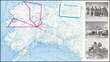
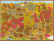
Scarce pictorial map showing southern Alaska and the western Yukon territory, designed to advertise White Pass and Yukon Route, which links Skagway, Alaska with Whitehorse via railway, and Whitehorse to Nenana (back in Alaska) via steamship on the Yukon. From there, passengers can take the Alaska Railroad down to Seward or the highway to Valdez.
The map is attractively designed, including many pictorial elements showcasing Alaska's wildlife and scenery. The verso includes several photographs and text describing the journey, although a misprint has led to the text finishing mid-sentence.
The reference to Soapy Smith's Skull, a painted rock near the Skagway water, dates the map to post-1928. Soapy Smith was a con man in Colorado who moved to Alaska following the Klondike Gold Rush. Having already made for himself fighting against the governor of Colorado alongside several renegade police officers barricaded in City Hall, he was unwelcome in Skagway when he arrived and was hunted down and shot by a vigilante committee after pulling several cons.
![Los Angeles Ambassador [Hotel Ambassador]](https://storage.googleapis.com/raremaps/img/small/97008.jpg)