|
||

|

|
|

|
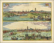
Important Base of Operations for French Piracy in the late 17th Century
Finely executed hand drawn plan of the fortified town and port of Dunkerque (Dunkirk) at the height of its importance as a base of operations for French Corsairs in the late 17th and early 18th Centuries. The map shows Dunkerque "in 1706 before it was demolished", with a general orientation showing south toward the bottom of the map.
Prior to the demolition of its fortifications in 1713, Dunkirk was an important base of operations for state sponsored piracy (Corsairs), including Jean Bart and other famous French corsairs who pillaged foreign ships.
Dunkerque During The Age of Corsairs
Dunkerque came under French rule when King Charles II of England sold it to France for £320,000 in October 1662. The French government developed the town as a fortified port. The town's existing defenses were adapted to create ten bastions. The port was expanded in the 1670s by the construction of a basin that could hold up to thirty warships with a double lock system to maintain water levels at low tide. The basin was linked to the sea by a channel dug through coastal sandbanks secured by two jetties. This work was completed by 1678. The jetties were defended a few years later by the construction of five forts, Château d'Espérance, Château Vert, Grand Risban, Château Gaillard, and Fort de Revers. An additional fort was built in 1701 called Fort Blanc. The jetties, their forts, and the port facilities were demolished in 1713 under the terms of the Treaty of Utrecht.
![[Rhine River Region -- Basle to Strasbourg]](https://storage.googleapis.com/raremaps/img/small/75443.jpg)
![(First state!) [ Rhine River Valley ] Tertia Rheni Nova Tabula](https://storage.googleapis.com/raremaps/img/small/96984.jpg)