|
||

|

|
|

|
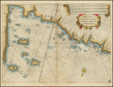
Finely executed plan of the city of Brest by P.L. Bermont, published by Jean Lattre in Paris 1779, along with a broader map of the harbor and surrounding water around Brest.
Brest is one of the most important maritime and naval centers in Bretagne.
The present example is finely colored, illustrating the fortifications around the city, with a detailed look at the primary buildings on the port.
Jean Lattré (fl. 1743-1793) was a Parisian bookseller and engraver who published many maps, plans, globes, and atlases. He worked closely with other important French cartographers, including Janvier, Bonne, and Delamarche, as well as other European mapmakers, such as William Faden, Santini, and Zannoni. Lattré is also interesting due to his propensity to bring suits against those who copied his work; plagiarism was common practice in eighteenth-century cartography and mapmakers struggled to maintain proprietary maps and information.