|
||

|

|
|

|
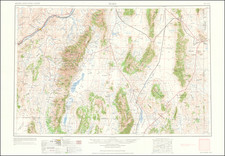
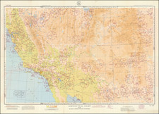
Large and highly detailed map of Nevada, issued by the General Land Office under the direction of Charles Roeser.
This map is the largest and most detailed map of Nevada published to date, and includes the most up to date details produced by the General Land Office. The topographical and Indian Reservation detail is especially noteworthy.
The map highlights in yellow the Indian Reservations in Nevada, located on Walker Lake, Pyramid Lake and the Duck Valley Reservation.
The map focuses on topographical details, early settlements, mines, roads, etc. Other details on the map include:
- Indian Reservations
- Surveyor General's Office
- Land Offices
- County Seats
- Completed Railroads
- Railroad Land Grant Limits
- Military Reservations
The General Land Office (GLO) refers to the independent agency in the United States that was in charge of public domain lands. Created in 1812, it assumed the responsibilities for public domain lands from the United States Department of the Treasury. The Treasury had overseen the survey of the Northwest Territory, but as more area was added to the United States, a new agency was necessary to survey the new lands.
Eventually, the GLO would be responsible for the surveying, platting, and sale of the majority of the land west of the Mississippi, with the exception of Texas. When the Secretary of the Interior was created in 1849, the GLO was placed under its authority. Until the creation of the Forest Service in 1905, the GLO also managed forest lands that had been removed from public domain. In additional to managing the fees and sales of land, the GLO produced maps and plans of the areas and plots they surveyed. In 1946, the GLO merged with the United States Grazing Service to become the Bureau of Land Management.
![[The Indian Tribes of California] Karte Übersicht zur Verbreitung der Indianer-stämme in Kalifornien](https://storage.googleapis.com/raremaps/img/small/96549.jpg)