This item has been sold, but you can enter your email address to be notified if another example becomes available.


|
||

|

|
|

|
Stock# 76501
Description
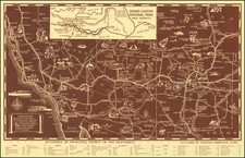
Scarce early road map of Phoenix, Arizona, first prepared in 1928, with this example issued in December of 1936.
The map shows Phoenix at a much-reduced scale compared with its current footprint; it is essentially contained by the Maricopa and Grand Canals in the north and the Salt River in the south.
On the verso is a 1929 bird's-eye view of Phoenix and the Salt River Valley by T.A. Hayden. It shows the Granite Reef Diversion Dam and the small towns of Scottsdale, Tempe, Mesa, Chandler, and Gilbert. Paradise Valley is labeled but was almost entirely uninhabited desert.
It was issued as a promotional item for The Lightning Delivery Co. a moving and storage company in Phoenix.
Condition Description
Folding map printed on both sides.
![[Grand Canyon -- Horseshoe Bend] Sketch Map of the Western Part of the Plateau Province Showing the Faults of the Grand Cañon District and High Plateaus](https://storage.googleapis.com/raremaps/img/small/35541.jpg)