|
||

|

|
|

|
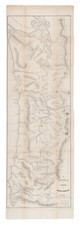
One of the Earliest "Forest Visitor Maps" issued by the US Department of Agriculture
Scarce separately published forestry map of the Olympic National Forest, published by the U.S. Department of Agriculture.
This is one of the earliest forest visitor maps published by the US Department of Agriculture, which first began issuing these maps in 1914.
On the verso is an extensive guide to the public, including rules on hunting, camping, hiking, and including "Six Rules For Prevention of Fires In The Mountains," along with other useful information. The present example includes a pastedown set of corrections on statistical information for 4 regions in and out of the National Forest.
The map bears the note "Traced by E.J.H. May 1915." The city directory for Olympia, Washington, the Supervisor’s Headquarters for the Olympic National Forest, lists Edward J. Hanzlik as being a “Forest Examiner” for the U.S. Department of Agriculture at the time of his 1915 map of the Olympic National Forest was issued.
The legend incudes over 2 dozen symbols, including:
- Ranger Stations, Cabins, Fireboxes
- Post Offices and Settlements
- Hotels & Stores
- Docks
- Telephones and telephone roads, lines and trails
- Railroads
- Wagon Roads
- Mines
Forestry Maps
The following are drawn from the excellent essay The Mapping of Our National Forests by Peter Stark, a Grey Tower Scholar-in-Residence in the Winter of 2014. The full essay can be found here: https://forestservicemuseum.org/wp-content/uploads/2019/11/Mapping-the-National-Forests-Nov19.pdf
Forest Reserve maps were first issued by the General Land Office in the 1890s and early 1900s and were typically small in scale and without significant detail. Generally, these were not distributed to libraries or the public. Following the May 1, 1897 report of the National Academy of Sciences Commission, the US Geological Survey was charged with surveying forests with an eye towards discovering which lands should be eliminated and which lands should be included in the nation’s forest reserves. The Commission thought that the U.S. Geological Survey was the only federal bureau at the time capable of performing such surveys and that the agency should be appointed with an adequate budget to map and inventory the forest reserves.
On July 18, 1898, the Director of the U.S. Geological Survey, Charles D. Walcott, officially transmitted for publication as Part 5 of the Survey’s Nineteenth Annual Report, 1897 – ’98, a 400-page volume on “Forest Reserves” with 110 maps and a large number of photographs. For the next two years, the U.S. Geological Survey’s substantial Annual Report included a Part 5 devoted to an examination of the Forest Reserves.
In 1905, the work of examining forest reserves, etc., together with the men employed upon it, was transferred to the Bureau of Forestry of the Department of Agriculture. The Department of Agriculture would focus most of its efforts on creation of a national Forest Atlas, released in folios. However, it also quickly adopted a decentralized approach to production of maps, relying upon the local forestry offices to create maps which made sense for their regions. The principal of a decentralized administration was championed by Henry S. Graves when he was appointed Forester in 1910. However, when Graves assumed his post as Forester, most mapping was still done in Washington, DC. While some drafting and map work was conducted in the district offices, and a small amount necessarily on the Forests, most work was still done in Washington, DC.
Methods of mapping were outlined in such early publications as the Use Book and National Forest Manual and Instructions for making Forest Surveys and Maps first published in 1907, with a second edition released in 1910. The first edition served as a manual of surveying and map-making in the field. The edition of 1910 added a chapter on preparing sheets for the Forest Atlas. An enlarged third edition appeared in 1912 with a supplement, Signs, Symbols, and Colors, prepared by the Office of Geography.
Forest Service mapping from the period 1910 to 1922 varied greatly from district to district. By 1910 with most forest atlases now complete and with responsibilities for their maintenance placed at the district level, it became necessary for each district to recruit and hire cartographers and draftsmen capable of making and revising maps as well as making township and control surveys in the field. Each Forest Service District could determine its mapping priorities, but Washington enforced map standards and arranged for engraving and printing services. After 1916, District cartographers were more often cited on Forest Service maps as the entity that compiled the maps while the Washington office continued to arrange for drafting and printing work. The Forest Service did not have its own printing plant and relied during this period almost exclusively on the engraving and printing services of the U.S. Geological Survey for its map production and, to a lesser extent, on the services of the Government Printing Office, both in Washington, D.C.
Beginning in 1914, the first 7 "Forest Visitor Maps" were produced, following by 11 in 1915, 24 in 1916, 15 in 1917, and 4 in 1918.
After 1918 and until about 1924 the uniformity of forest visitor maps ended as national forest districts produced a wide variety of non-standard maps and publications for their users with more printing done by the Government Printing Office. District 5 created a series of small-scale road maps for the national forests of California similar in size and format to the “in and out” maps that the Southern California Automobile Club published at the time for western cities. This series used the common title of “Automobile Route Map of the…. National Forest or Forests” as the case may be, on the map’s title panel. The maps represented a significant departure from the large-scale folded forest visitor maps published between 1914 and 1918. Districts 3, 4, and 7 each issued recreation maps covering their districts as a whole, as in the 1922 map, National Forests, District 3, Showing Main Highways, or a large portion of their territory, such as District 4’s Recreation map of the National Forests of South Central Idaho also issued in 1922. In 1919, District 2 issued nine forest visitor booklets for its national forests complete with text, photographs, and a sketch map folded and inserted at the back of the booklet, all printed by the Government Printing Office. District 6 also produced a number of booklets with maps for the forest visitor folded inside the back cover. These were included in the Department of Agriculture’s Departmental Circular series as “Contribution from the Forest Service.” Finally, the Northern District produced a series of four, 1:500,000-scale “Quadrangle” maps for the public covering the heart of the northern Rocky Mountains between 1922 and 1924.
Rarity
Pre-1920 Forest Visitor Maps are rare on the market.
This is the first example of the Olympic National Forest map we have offered for sale.
![Pacific Coast Highways Canada to Mexico [Texaco Tour Maps Routes and Mileages Canada to Mexico]](https://storage.googleapis.com/raremaps/img/small/91594.jpg)