The item illustrated and described below is sold, but we
have another example in stock. To view the example which
is currently being offered for sale, click the
"View Details" button below.


|
||

|

|
|

|
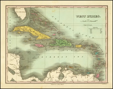
Stock# 76456
Description
Antique engraved general map of the Caribbean, published by Matthew Carey in his General Atlas.
This map was made in 1814 when the U.S. was just expanding its naval footprint into the Caribbean as a result of the War of 1812.
The first tours of duty by the United States' first frigates were around Hispaniola.
Condition Description
Original hand-color. Extensive, relatively early annotations in pencil and pen. Wide margins. Some soiling.
![The Island of Cuba [with] Hayti or Santo Domingo and Porto Rico [with] The Leeward or North Caribee Islands](https://storage.googleapis.com/raremaps/img/small/78673.jpg)
![[British Colonies in America] Carte Qui Contient Une Description Des Iles & Terres Que Les Anglois . . .[maps of Chesapeake, Carolinas, New England, Bermuda, Gulf Coast, Jamaica, Barbadoes & Canada]](https://storage.googleapis.com/raremaps/img/small/61480.jpg)
![[Heighted with Gold] Pascaert Vande Caribes Eylanden](https://storage.googleapis.com/raremaps/img/small/91150.jpg)