


|
||

|

|
|

|
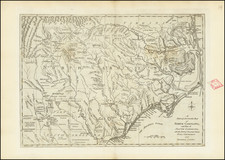
One of the earliest obtainable maps of Virginia published in the United States. This map was published in Reid's American Atlas, the second commercial atlas to be made of the new country.
The map, which shows a still-joined Virginia and West Virginia, stretches from the Chesapeake Bay to Kentucky. Detail grows sparser as the map moves inwards, with only the occasional river branch punctuating the subparallel chains of the Appalachians shown
In the northern part of the map, an insight into the very early layout of Washington can be seen, with city blocks overexaggerated in size. The nation's capital had only been announced five years earlier, and maps of the city only started appearing a year or two before the present map.
Reid's map shows counties, towns, roads, rivers, lakes, islands, harbors, bays, courthouses, along with topographical details.
Following Mathew Carey’s publication of the American Atlas in 1795, the second large format atlas published in America was produced by John Reid of New York in 1796. The project began as an atlas to accompany William Winterbotham’s An Historical, Geographical, Commercial and Philosophical View of the United States, but was also sold separately under the title The American Atlas.
Reid’s atlas included 20 maps. In addition, John Russell’s plan of Washington, D.C. is also bound into some copies of the Atlas. Reid’s atlas was a collaborative work, with 9 of the maps engraved by Benjamin Tanner, 5 by David Martin, two by D. Anderson and one each by John Scoles and John Roberts. Two of the maps do not include engraving credits. Each of the engravers was probably working in New York (including Tanner, who had not yet relocated to Philadelphia). According to the various entries for the maps in Wheat & Brun, the cartographic content of the maps is drawn largely from Carey’s first atlas of 1795.

![[ Pictish Warrior Woman ] Feminae Pictae icon V](https://storage.googleapis.com/raremaps/img/small/99648.jpg)
![[ Port Royal, South Carolina ]](https://storage.googleapis.com/raremaps/img/small/81298.jpg)
