|
||

|

|
|

|
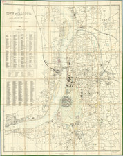
Decorative and detailed birdseye view of the city and harbor of Goa, published by De Bry, based upon an earlier map of the same region by Jan Linschoten. The view is attractive, showing numerous ships at sea as well as an expansive city with numerous large avenues.
Linschoten Map of Goa
Linschoten served for six years as the bookkeeper for the Archbishop of Goa (1583-89). While in Goa, as a result of his position, Linschoten had access to secret information, including the nautical maps that had been well guarded for over a century. Misusing the trust in him, he began meticulously copying these maps. In 1587, the Archbishop of Goa died while on a trip to Lisbon to report to the King of Portugal, ending Linschoten's stay in Goa. He set sail for Lisbon in January, 1589, passing by the Portuguese supply depot at St. Helena island in May 1589.
Linschoten was "one of the pathfinders for the first Dutch voyages to the East" (Schilder, p. 195). He was in the service of the Portuguese as Secretary to the Portuguese Archbishop of Goa in India from 1583 to 1589. Here, he had access to many Portuguese portolans as well as other valuable commercial information, especially as Goa at this time was the commercial and political center for the Portugal Empire in the East. Van Linschoten left Goa for home in January 1589. On the way to Portugal, his ship was pursued by an English fleet and lost its cargo in a storm while anchored off the Azores. After the loss of the cargo, Van Linschoten was persuaded to stay and help recover it; he spent two years on Tercera, working and preparing his notes from Goa. Van Linschoten eventually arrived in Lisbon early in 1592, and then sailed home to The Netherlands. His account of his experiences is one of the most important travel works of the period and was republished by De Bry in 1613.
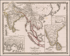
Controversy on the Exact Location of Goa
The mapping of Goa as a single city is of particular interest. Goa now refers to a state in western coastal India, which was a Portuguese colony until 1961, and the name Goa was conferred to several different cities historically. In modern times, the term Old Goa has been bestowed on several different areas, though historical use of this term within the state is limited. No modern Goan city has the same layout as that which is shown in this map, though clues can help identify what this view likely was meant to show.
Insula Dyvar is almost certainly Divar Island, which lies several miles upriver along the Mandovi of the modern-day capital of Goa, Panaji. An adjacent peninsula that lies upriver is named Narve, though its low topography and marshes could lead to it being confused for an island. Charao [likely Ins. Chora on the map] is another place name in the immediate area of the Mandovi. A modern view from across these islands would leave one looking at the area now known as Old Goa, "Velha Goa," which at present comprises several churches and other historic buildings scattered around an area mostly dominated by fields and forests.
Several landmarks in this map are recognizable, for example, there is a Church of St. Francis near the water, and a shrine sits on the hills to the east, though it is now dedicated to Our Lady of the Mount, not St. Bras as shown in the index. This area used to be one of the central trading hubs of Portuguese Goa, encompassing a population of up to 200,000, until it was abandoned in the 18th century due to a plague. The palace of the Viceroy of Goa (place 11 on the map, along the river) was moved in 1759 to Panaji, a city then known as "Nova Goa." Works such this birdseye view, alongside a few surviving scattered buildings and archeological sites, are all that remain of this once great city.
Theodor de Bry (1528-1598) was a prominent Flemish engraver and publisher best known for his engravings of the New World. Born in Liege, de Bry hailed from the portion of Flanders then controlled by Spain. The de Brys were a family of jewelers and engravers, and young Theodor was trained in those artisanal trades.
As a Lutheran, however, his life and livelihood were threatened when the Spanish Inquisition cracked down on non-Catholics. De Bry was banished and his goods seized in 1570. He fled to Strasbourg, where he studied under the Huguenot engraver Etienne Delaune. He also traveled to Antwerp, London, and Frankfurt, where he settled with his family.
In 1590, de Bry began to publish his Les Grands Voyages, which would eventually stretch to thirty volumes released by de Bry and his two sons. The volumes contained not only important engraved images of the New World, the first many had seen of the geographic novelties, but also several important maps. He also published a collection focused on India Orientalis. Les Grands Voyages was published in German, Latin, French, and English, extending de Bry’s fame and his view of the New World.