


|
||

|

|
|

|
Stock# 76385
Description
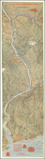
Handsome map of lower Puget Sound, Washington, showing the ferry routes from Tacoma to islands adjacent, including Vashon, Fox, McNeil, Anderson, and the Kitsap Peninsula.
The map was issued by the Washington Navigation Company, a big promoter of this kind of stylized-realism in mapmaking in the 1910s-1930s.
The other works associated with the Washington Navigation Company are more common, though highly sought-after, than this much scarcer map.
Condition Description
Folding map printed on front and back.
![[San Francisco to British Columbia] Carta particolare dello stretto di Iezo fra l'America e I'Isola Iezo . . . D'America Carta XXXIII](https://storage.googleapis.com/raremaps/img/small/67788.jpg)
![[ Pacific Northwest - Northwest Passage ] Limes Occidentis Quivira et Anian. 1597](https://storage.googleapis.com/raremaps/img/small/71207.jpg)
![(United States Takes Possession of the Columbia River) [Manuscript Description of 21-Gun Salute Upon Captain James Biddle Taking Possession of the Oregon Country for the United States at Entrance to Columbia River, on the U.S.S. Ontario; With Original Watercolor of Cape Disappointment]](https://storage.googleapis.com/raremaps/img/small/98901.jpg)
![[ Whidby Island, Washington ] Penn Cove Park: your homesite on Whidby Island. . . [with five printed photos of Whidby Island streets including four aerial shots].](https://storage.googleapis.com/raremaps/img/small/98838.jpg)