This item has been sold, but you can enter your email address to be notified if another example becomes available.


|
||

|

|
|

|
Stock# 76343
Description
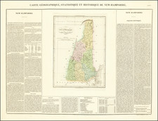
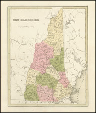
Nice example of Mathew Carey's map of New Hampshire which first appeared in his American Atlas.
The present map is highly detailed, showing towns, rivers, roads, counties, colleges, mills, forts and other details. Relief is shown pictorially. A note adjacent to the White Hills [Mountains] in the northern part of the state says that they "appear many leagues off at sea like White Clouds: just rising above the horizon," suggesting that these are visible from the ocean.
Carey first published his American Atlas in 1795, which became the first folio atlas published in America. He issued later General Atlases in 1796 and after. In 1814, he became the first American publisher to offer hand coloring.
An essential map for New Hampshire collectors.
Condition Description
Original hand-color, retouched.
![(California Gold Rush Artist) [Autograph Letter, from American artist William McIlvaine Jr. to artist William Thompson Russell Smith, mentioning Fronconia Notch. White Mountains]](https://storage.googleapis.com/raremaps/img/small/97179.jpg)