


|
||

|

|
|

|
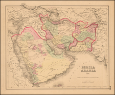
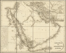
Fascinating Treatment of Region Centered on Arabia and the Gulf
Interesting map of Arabia, the Ottoman Empire, Persia , Afghanistan, Beloochistan and contiguous regions, published in New York by GW & CB Colton.
The southern coast of the Gulf is called El Ahsa or El Hejer, shortly before the so-called Al-Hasa Expedition of 1871, which resulted in Medhat Pasha's extending his influence of the Ottoman Empire to the region a and reincorporated into the Ottoman Empire and became known as the Najd Sanjak.
Sharjas Tower is named, as is Dibbah (Dubai), Abothubbee (Abu Dhabi) and Ras al Khyme in the UAE region.
Near Qatar and Bahrein, Ras Aufir, Zabarah, El Katif and Duat are named, with the Great Pearl Bank, Goodwin's Island and Dahnyi Island shown.
G. W. & C. B. Colton was a prominent family firm of mapmakers who were leaders in the American map trade in the nineteenth century. The business was founded by Joseph Hutchins Colton (1800-1893) who bought copyrights to existing maps and oversaw their production. By the 1850s, their output had expanded to include original maps, guidebooks, atlases, and railroad maps. Joseph was succeeded by his sons, George Woolworth (1827-1901) and Charles B. Colton (1831-1916). The firm was renamed G. W. & C. B. Colton as a result. George is thought responsible for their best-known work, the General Atlas, originally published under that title in 1857. In 1898, the brothers merged their business and the firm became Colton, Ohman, & Co., which operated until 1901, when August R. Ohman took on the business alone and dropped the Colton name.
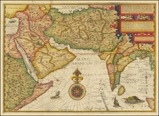
![[ Arabia ] Carte Des Trois Arabies Tiree en Partie de l'Arabe de Nubie, en partie de divers autres Autheurs . . . 1654](https://storage.googleapis.com/raremaps/img/small/99810.jpg)