


|
||

|

|
|

|
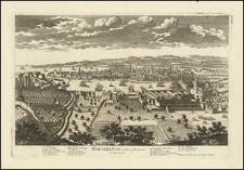
Attractive navigational chart showing the town of Marseille, in Provence (France). Delicately colored, the map includes numerous soundings and shows onshore details which would have been of use to sailors, for example, towns and topography. The layout of the city is hinted at, with major thoroughfares shown. Notre-Dame de la Garde is labeled and shown, it was a Medieval chapel at the time and would be transformed into the Basilica and symbol of Marseille in the 19th century. Several islands are also shown and named.
Marseille is one of the most merchant port centers on the Mediterranean, and, in the 18th century, it served as a gateway between France and Italy as well as the Middle East. In 1764, the city was just recovering from its great plague of 1720, but, by 1792 the city would be the center of world events as one of the focal points for the French Revolution.
The map appeared in Jacques Nicolas Bellin's Le Petit Atlas Maritime Recueti de Cartes et Plans des Quatre Parlies du Monde en Cinq Volumes, first published in Paris in 1764. The Atlas was a delightful small-sized pilot, showing many places of interest around the world.
Jacques-Nicolas Bellin (1703-1772) was among the most important mapmakers of the eighteenth century. In 1721, at only the age of 18, he was appointed Hydrographer to the French Navy. In August 1741, he became the first Ingénieur de la Marine of the Dépôt des cartes et plans de la Marine (the French Hydrographic Office) and was named Official Hydrographer of the French King.
During his term as Official Hydrographer, the Dépôt was the one of the most active centers for the production of sea charts and maps in Europe. Their output included a folio-format sea atlas of France, the Neptune Francois. He also produced a number of sea atlases of the world, including the Atlas Maritime and the Hydrographie Francaise. These gained fame and distinction all over Europe and were republished throughout the eighteenth and even in the nineteenth century.
Bellin also produced smaller format maps such as the 1764 Petit Atlas Maritime, containing 580 finely-detailed charts. He also contributed a number of maps for the 15-volume Histoire Generale des Voyages of Antoine François Prévost.
Bellin set a very high standard of workmanship and accuracy, cementing France's leading role in European cartography and geography during this period. Many of his maps were copied by other mapmakers across the continent.
![[ South France ] The South Eastern Part of France which includes Roussillon-Languedoc, with a Great Portion of Rouergue and Auvergne-Provence-Dauphine, and the Whole Frontier of Italy](https://storage.googleapis.com/raremaps/img/small/102796.jpg)
![[ Provence ] Comte Et Gouvernement de Provence](https://storage.googleapis.com/raremaps/img/small/103392.jpg)