|
||

|

|
|

|
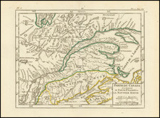
The First State of the First and Most Highly Sought After Sea Chart of Nantucket and Martha's Vineyard. With Provenance to Captain James Sever, one of America's First Six Frigate Captains.
Des Barres's chart centers on Nantucket, eastern Martha's Vineyard, and the surrounding waters, with particular attention given to the Sound separating the islands from Cape Cod. The detail is extraordinary, including both the surrounding waters as well as the island's natural and human topography. A tiny street plan of Nantucket Town is clearly visible, and numerous landmarks on both islands are identified by name.
This is Stevens's first of 8 states of the chart. This first issue was hurried into print in June of 1776 for use by British navigators during the opening stages of the American Revolution. This state lacks much of the hydrographic detail that would come to characterize the later editions of the chart, which in its latest states becomes busy with soundings, shoals, and terrestrial detail. Des Barres repeatedly revised and improved the plate, pulling new impressions at least through 1781 and probably much later.
The more detailed bathymetric information was probably derived from John Knight's surveys of 1778, which naturally did not make it into this state of the chart.
Des Barres' chart was the first published map of Nantucket and Martha's Vineyard. Its extraordinary accuracy and level of detail were not exceeded until the United States Coast Survey began to chart the area in the mid-19th century.
Rarity
All examples of the Des Barres Nantucket chart are rare, but we are unaware of another example of the first state ever having been offered on the market.
The Revolutionary War Mapping of Nantucket and Martha's Vineyard
In his book The First Mapping of America, Alexander Johnson explains the nature of the survey work that led to the creation of this chart:
The naval high-command in the American theatre was well aware of the hydrographical shortcomings of the New England surveys and sought to ameliorate the situation. From 1776 to 1778, commander-in-chief of the Royal Navy's North American Station Admiral Richard Howe's secret instructions to all his captains for 'collecting material Intelligence and making useful Discoveries... of the Pilotage and Navigation on the most inaccessible Coasts within the limits of your Station'. John Knight was charged with surveying the critical stretch of coastline extending from New York Harbour to the Nantucket shoals. His magnificent chart 'Buzzards Bay and Shoals of Nantucket' precisely employed the Northern Survey's delineation of the coastlines, but added great hydrographical detail.
During the first 18 months of the war, the British strategy in Maine, and indeed for all of the New England coastline north of Cape Cod, was to maintain a naval blockade, while mounting punitive raids 'to chastise' certain particularly rebellious towns. Henry Mowat, who had since been promoted to captain, would, to his professed chagrin, be placed in charge of the naval operation in Maine from 1775 to 1780, having been described by Admiral Molyneux Shuldham as 'the most useful person perhaps in America for the service we are engaged in by his perfect knowledge of all the harbours on this coast, which he has been employed in surveying these last twelve years'. In that role he would gain infamy (at least in American eyes) as the protagonist of Britain's revenge campaign for burning two-thirds of Falmouth, Maine to the ground on 18 October 1775.
Des Barres would not print any charts relating to coasts of New England that lay to the north of Boston until the spring of 1776 (and the first of these would not arrive in America until months later). However, there is evidence that the Royal Navy had some access to certain Northern Survey maps. For instance, the Cape Ann area of Massachusetts, was a major base for American privateers and blockade-runners, and for this reason its primary port of Gloucester was the target of a raid by the Royal Navy in August 1775. Sometime early in 1776, a British sailor drafted a bespoke manuscript map of the peninsula, clearly based on a copy of Grant and Wheeler's original manuscript, but after which also included additional 'Soundings ... [and] observations', supplied by Mowat, that were not on the original manuscript that had been submitted to the Board of Trade.
J.F.W. Des Barres and The Atlantic Neptune
Des Barres chart of Nantucket and Martha's Vineyard was issued both separately and in The Atlantic Neptune, an atlas of charts and views of North American waters used by British navigators throughout the Revolution. The charts were of extraordinarily high quality and remained the standard for decades, becoming the standard reference work for cartographic information used by American and European engravers and publishers for decades thereafter. On a broad scale basis, it was not until the United States Coast Survey commenced issuing maps in the middle of the 19th Century that a more detailed and systematic charting of the Northeast was made under the auspices of a single project.
The charts of the Atlantic Neptune which focus on New England were based on work overseen by Samuel Holland, a Dutch-born surveyor and engineer who entered British service during the French and Indian War. After the war, Holland had proposed "an accurate and just Survey… upon… a general scale and uniform plan" of North America east of the Mississippi. This was to be a "geodetic" survey following the most advanced methods then in use in Europe, but applied for the first time in North America: the locations of control points would be established by rigorous astronomical observation, intermediate areas pinpointed by triangulation, and details sketched in from direct observation.
Holland's proposal was approved by the British Colonial offices, and in 1764 Holland was named Surveyor General of both the Province of Quebec and the Northern District of North America, from the Potomac to the border with Canada. After several years work in the Canadian Maritimes, from 1770-1774, he focused on the New England coast, making his headquarters in Portsmouth. From Portsmouth, Holland sent out survey teams headed by his deputies Charles Blaskowitz, James Grant, George Sproule, Thomas Wheeler and Thomas Wright, utilizing the sloop HMS Canceaux.
Holland's finished surveys were sent to England, where Des Barres oversaw the work necessary for their engraving and publication. The demand for charts was high in those unsettled times, and Des Barres' operation soon occupied two townhouses and 20 assistants in compiling, drafting and correcting the charts. While The Atlantic Neptune was usually made up to order and had no standard collation, it ultimately extended to five sections: Nova Scotia, New England, the River and Gulf of St. Lawrence (based on the work of James Cook), the coast south of New York, and American coastal views.
Des Barres' Nantucket chart is very rare on the market and all-but unobtainable in such superb condition. The most recent example to change hands was an inferior, uncolored example at Rafael Osona Auctions for ca. $66,000 in 2014. The most recent impression recorded by Antique Map Price Record was sold by the firm of Martayan Lan in 1994.
Provenance: Captain James Sever
We acquired this map in October 2020 from the descendants of James Sever, Captain of the USS Congress, one of the famed first six frigates of the U.S. Navy. Captain Sever was born in 1761, attended Harvard, and upon graduation received an ensign's commission in the 7th Massachusetts Regiment (February 1, 1781) during the Revolutionary War. Sever later transferred to the 4th Massachusetts Regiment and remained in the Continental Army until June 20, 1784. Sever was from a successful Massachusetts merchant family, and that background along with his military experience was enough for him to be named the superintendent of the USS Congress during its construction in 1795. In 1798, he became one of the first six post captains of the U.S. Navy. Sever served in the first foreign action of the U.S. Navy, when the Congress was involved in privateer hunting in the Caribbean and the U.S. intervention in the Haitian War of Knives. Sever had a relatively short career in the Navy and was dismissed during Jefferson's purge of the officer corps in 1801.
Joseph Frederick Wallet Des Barres (1721-1824) was born in either Paris or Basel, Switzerland, to a Hugueont family. He studied under the great mathematician Daniel Bernoulli at the University of Basel before immigrating to Britain, where he trained at the Royal Military College, Woolwich.
Upon the outbreak of hostilities with France in 1756, he joined the British Royal American Regiment as a military engineer. He came to the attention of General James Wolfe, who was impressed with his charting ability. During this period, he also worked with the legendary future explorer, James Cook, on a monumental chart of the St. Lawrence River.
Des Barres is best known for the Atlantic Neptune, was a remarkable, multi-volume set of sea charts and coastal views prepared from recent surveys, some of which were overseen by Des Barres in Nova Scotia after the Seven Years’ War. The maps, charts, and views were prepared under the supervision of Des Barres and employed as many as twenty engravers and assistants. They were produced over the course of a decade, from 1774 to 1784, in time to be used by the Royal Navy in the American Revolution.
After the Revolution, Loyalists were resettled throughout Canada. As part of this process, a new colony was created by separating Cape Breton from Nova Scotia. Des Barres, who already owned extensive lands in the Maritimes, served as lieutenant governor of Cape Breton Island from 1784 to 1787. He later served as governor of Prince Edward Island from 1804-1812.
Des Barres lived an exceptionally long life, even by today's standards, finally dying at age 102. Des Barres' funeral was held at St. George's Round Church in 1824 and he is buried in Halifax.


![South Carolina and Parts Adjacent; Showing The Movements of the American and British Armies [from Ramsey's History of the Revolution in South Carolina]](https://storage.googleapis.com/raremaps/img/small/83798.jpg)