|
||

|

|
|

|
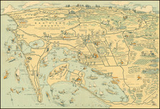
Important survey of the region south of San Diego along the Tijuana River, forming the initial boundary for the treaty map which accompanied the Treaty of Guadalupe Hidalgo in 1849.
Following the conclusion of the Mexican-American War in 1846, the two countries commenced a series of surveys to establish a new border. Unfortunately, as a result of many errors, the line was drawn substantially inaccurately, which resulted in the subsequent Gadsden Purchase.
The map extends from the southern part of the modern location of Tijuana, showing Camp Riley, Infantry or Hayden Camp, Camp Rough & Ready, Mexican Camp, Gray's Encampment in Sept. 1849, a Deserted Ranch in the Otay area, Achilld's Ranch, several roads and other interesting details.
One of the earliest and most important regional San Diego maps.
![[ Baja California ]](https://storage.googleapis.com/raremaps/img/small/85440.jpg)
![[Monterey] Plan De La Baie De Monterey Situee Dans La Californie Septentrionale . . .](https://storage.googleapis.com/raremaps/img/small/99008.jpg)
![Air Log Western Air Express [Los Angeles-San Diego, Las Vegas-Los Angeles, Milford-Vegas, Salt Lake City-Milford]](https://storage.googleapis.com/raremaps/img/small/85953.jpg)