


|
||

|

|
|

|
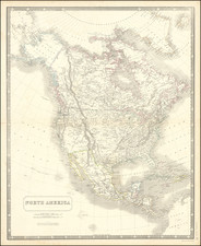
Marvelously detailed map of North America, featuring several transitional western borders, an early, misconfigured Texas, Upper or New California (still called New Albion!), Oregon Territory, Western District (the first time we have seen the ephemera; Western Territory which would become Nebraska Territory referred to as a District), Mandan District, Osage District, massive Iowa, etc.
Marvelous detail. Annotation noting that the regions between the Mexican border and the Russian claims are claimed by both Britain and the United States, although the inclusion of the line established by the Treaty of Guadalupe Hidalgo (albeit inaccurate on the map) clearly makes this a post 1846 map, as does the identification of Sutter's Fort in California, suggesting that the Gold discoveries where then known to the maker. The American Fur Company Depot near Salt Lake is noted, are are other early forts and trading posts. The treaty lines of 1819 (Adams Onis) and 1828 are noted. The Oregon Trail and some other important early western routes are also located, as is a route north of the Rio Colorado, which seems to connect a number of early Spanish settlements in the region.
Despite the excellent detail, there are still remnants of the early mythical geographical features, including Inconstant River roughly in the area of the Mojave Desert and Death Valley and the remnants of the second (mythical) Salt Lake and the Rio Buenaventura, which while no longer connected to SF Bay, meanders southwest of Salt Lake, which is still badly misshapen. Rich detail throughout. Decorative Piano Key border.


![Nord-Amerika [North America]](https://storage.googleapis.com/raremaps/img/small/91328.jpg)