|
||

|

|
|

|
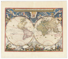
Large format antique engraved map of the world, issued by Pierre Mortier in Amsterdam circa 1703.
This map is a revised and enlarged version of one which Mortier had issued about a decade earlier, in 1693. It can be differentiated by the engraved signature of Baltasar Ruyter below the neatline on the left sheet.
The map includes a fascinatingly detailed - but erroneous mapping of northeast Asia. The Great Lakes are still incomplete and open to the West, and several antiquated cartographic myths persist, such a California as an Island and the inland lake in the American Southeast. The Strait of Anian is interrupted by a sea of ice between Hudson Bay and the Pacific.
Shirley (559) alludes to the present map in his discussion of the original Mortier edition of 1693:
A new map slightly larger in size but otherwise similar was engraved and signed by Baltasar Ruyter. It was published in 1703, and was reissued in the 1730s with the imprint of Covens and Mortier. North America follows state 2 of the 1693 map but north-east Asia has been redrawn in much more detail and has been considerably extended so that it almost touches the oval title frame in the top right-hand corner.
There second state (circa 1730) includes the imprint line on the left sheet: "Chez Jean Covens et Corneille Mortier Libraries | Avec Privilege de nos Seigneurs les Etats."
Baltasar Ruyter
Ruyter was a Dutch engraver active for several decades at the end of the 17th century and the beginning of the 18th. His output seems to have occurred between roughly 1680 and 1710. He worked primarily with Pierre Mortier and the firm of his son, Covens & Mortier.
Pierre, or Pieter, Mortier (1661-1711) was a Dutch engraver, son of a French refugee. He was born in Leiden. In 1690 he was granted a privilege to publish French maps in Dutch lands. In 1693 he released the first and accompanying volume of the Neptune Francois. The third followed in 1700. His son, Cornelis (1699-1783), would partner with Johannes Covens I, creating one of the most important map publishing companies of the eighteenth century.
![[Early Photographic Facsimile of the Rosselli-Sonetti Woodblock World Map] Figura & Scrittura in soma di tutti lo habitato](https://storage.googleapis.com/raremaps/img/small/66515.jpg)
![Tabula Geographica Hemisphaerii Borealis ad emenatiora quae adhuc prodieruntexampla jusqu Acad. Reg. Scient. et Eleg. Litt. Boruss. descripta [with:] Tabula Geographica Hemisphaerii Australis...](https://storage.googleapis.com/raremaps/img/small/81806.jpg)