|
||

|

|
|

|
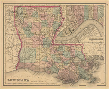
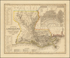
The first French Map of the State of Louisiana.
Detailed map of Louisiana, published by Buchon in Paris in 1825. This is the earliest map of the newly formed State of Louisiana published outside the United States, published shortly after the admission of the state into the union in 1812.
The map shows the counties, cities, rivers, roads, railroads, coastal swamps, and more of this southern state. The county layout within the state differs largely from what is seen today, with massive large western counties visible on the map, and, in particular, a very enlarged Opelousas County. The outer edges of the map include fascinating text regarding the agriculture, demographics, religion, schooling, and government of the state.
Jean Alexandre Buchon (1791-1849) was a French scholar and historian. Born as the French Revolution raged, Buchon was dedicated to recovering France’s history in order to help the country heal and grow. He gathered French stories and published them as part of Collection des chroniques nationales franciases ecrites en langue vulgaire, du XIe au XVIe siècle (4 vols, 1824-1829). He also compiled and published an exploration collection and several histories, particularly about medieval France.
For geography, his most important contribution was publication of the French edition of Carey & Lea’s American Atlas in 1825. Each page of the atlas includes highly detailed text about the state or territory depicted, as well as a map of the area. The French edition is generally considered in high regard as compared to other editions, as it has quality paper and superior engraving.