|
||

|

|
|

|
Stock# 76038
Description
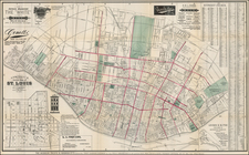
St. Louis in 1901
Detailed map of St. Louis, published by the Red Guide Publishing Company in 1901.
The map is a based upon an official map of St. Louis, prepared by Charles Varrelmann, Street Commissioner, who seems to have been serving in this capacity at the beginning of the 20th Century, although the earliest references to Varrelmann date back to a German newspaper published in St. Louis in 1876 and he seems to have been serving as an Engineer in the Street Department since the late 1870s.
Rarity
The map is apparently quite scarce. We were unable to locate another example.