|
||

|

|
|

|
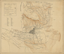
Very Rare Map of Tula By Mexico's Most Important Practitioner of Scientific Mapping in the Mid-Nineteenth Century
Fine, detailed, and extremely rare map of the district of Tula, in the State of Mexico. We can locate only two institutional examples of this map, which was part of the first atlas of the State of Mexico.
The map was made by Tomás Ramón de Moral, a skilled cartography and surveyor who worked on the first geodesic survey of the State of Mexico. The map was updated by the influential Sociedad de Geografía y Estadística, Mexico’s first geographical society.
The district, an administrative unit below the state level, is bordered to the south and east by other districts of the State of Mexico, which is in central Mexico. The map includes political and geographic information, including many mountains and hills drawn with hachures. A key in the lower left denotes local sites; it includes symbols for the state capital, partido (similar to a county) seats, parish seats, villages, haciendas, ranches, highways, and district, partido, and municipality boundaries.
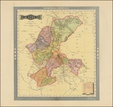
The first atlas of the State of Mexico
This map was part of the first atlas of the State of Mexico, a project undertaken by Ramón de Moral. At that time, the State covered the modern states of Hidalgo, Tlaxcala, Guerrero, as well as the modern State of Mexico. He and his colleagues with the Comisión de Estadística del Estado de México toured the countryside from 1827 to 1830 producing the first maps based on the first geodetic survey in Mexico. The maps were completed by 1833 but they were not published until 1851-2, four years after Ramón de Moral’s death.
De Moral had surveyed Taxco, Chilapa, and Acapulco as part of his original triangulation survey, but they had been carved out of the State of Mexico by 1849. As a result, when the atlas was published, it contained eight district maps and a four-sheet general map of the State. The maps were published in the following order: in 1851, Tula, Tulancingo, Texcoco, Cuernavaca, and Sultepec; in 1852, Huetjutla, Tlalnepantla, Toluca, and the general map.
The atlas also involved the Sociedad de Geografía y Estadística (Mexican Society for Geography and Statistics), who reviewed and corrected the maps. Founded in 1833, the Sociedad was the first geographical society in the Americas and only in the fourth in the world. The Society was established to create a cohesive map of the nation state of Mexico; the country was in urgent need of maps to define the borders and aid governmental agencies. The aim of their projects was to survey topography and natural resources, identify potential for development, and record demographic information.
The atlas was produced under the order of Don Mariano Riva Palacio (1803-1880), a prominent politician in nineteenth-century Mexico. A native of Mexico D. F., Palacio was married to the daughter of a hero of the Mexican War of Independence, General Vincente Guerrero. He began his political life as a City Councilor in Mexico D. F. before being elected a federal Congressman. He went on to serve as the Minister of Finance, Minister of Justice, and the Governor of the State of Mexico. Indeed, Palacio was three times the Governor, elected in 1849 (to 1851), 1857, and 1869 (to 1871). Interestingly, he was imprisoned during Santa Anna’s final presidency (1852-4) and was appointed as the lawyer to defend the deposed Emperor Maximilian, who was executed in 1867. Palacio is remembered for his work to develop Mexico’s law enforcement system, as well as its infrastructure. An atlas of the State of Mexico fits squarely within his interests to better know his state and within the state’s interest of development.
Finally, the atlas maps were lithographed by Placido Blanco. Blanco gained fame in Mexico D. F., where the firm worked on a variety of projects including the Revista Cientifica y Literaria (1845-46). In 1851, the business moved to Toluca to run the lithography works at the Instituto Literario, where the atlas maps were produced.
Rarity
The map is extremely rare, as very few examples of the atlas and its maps were ever printed. We locate only 2 examples, in the Bibliotheque National de France and Cornell.
Tomás Ramón de Moral (ca. 1791-1847) was an accomplished mapmaker known for his district maps of the State of Mexico, which were part of the first atlas of that state. He is considered one of the first scientific mapmakers in Mexico, due to his use of geodesy as part of the Comisión de Estadística del Estado de México.
De Moral served with the Corps of Engineers from 1822 to 1826 and he was also a professor at the School of Mines, two of the most important bodies associated with surveying and cartography in Mexico. He was also the author of the first book on geodesy published in Mexico; it appeared posthumously, in 1852, as did his maps.
De Moral performed the surveys of the State of Mexico and drew up manuscript maps in the late 1820s and 1830s. Due to a lack of state funds, his first map was only published in 1847, a reduced version of his map of Mexico D. F. The rest of his maps of the state’s districts were published in 1851 and 1852, several years after De Moral’s death. They were published as an atlas by the state government. Few copies of the atlas or its maps exist; there were eight district maps in the atlas along with a four-sheet map of the entire state.
![[ Earliest Obtainable Map of San Diego Bay ] Plan du Port De St. Diego en Californie. . . 1782 [with] Plan Du Port et du Departement de San Blas . . . 1777](https://storage.googleapis.com/raremaps/img/small/90982.jpg)
![(Mexican-Aztec Paintings) [Aztec Deities from the Codex Laud] Laud MSS (page 3). B65 nunc 678. Aglio 2 Vol.](https://storage.googleapis.com/raremaps/img/small/102323.jpg)