This item has been sold, but you can enter your email address to be notified if another example becomes available.


|
||

|

|
|

|
Stock# 75997
Description
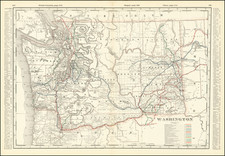
Striking Large Forestry Map of Washington
Scarce large format map of Washington, illustrating land classifications for the State of Washington.
The land classifications are focused on the density of timber, ranging from "cut areas" "burned areas" and "timberless areas", to areas with 50,000 to 100,000 B.M. per acre (Board Measure).
The map was issued with revisions in 1902.
Condition Description
Two sheets, joined as issued. Evidence of old splits and some minor toning in certain sections.
![[ Lake Hancock / Middle Fork Snoqualmie River / Kings County ] Township No. 24 North, Range No. 9 East. Willamette Meridian, Washington](https://storage.googleapis.com/raremaps/img/small/101646.jpg)
![[British Columbia]. Routes of the Canadian Pacific Railway Company's Steamers British Columbia Coast Service](https://storage.googleapis.com/raremaps/img/small/83915.jpg)
![[Columbia Basin Irrigation Project] Panoramic Perspective of the Spokane Region including the Geological and Scenic Wonderland Embracing the Columbia Basin Irrigation Project and Coulee Dam . . . 1946](https://storage.googleapis.com/raremaps/img/small/77423.jpg)